The coastlines States of India including their total length, coastal states and Union Territories, major features and their significance for trade, economy, biodiversity, fisheries, tourism and maritime security. Learn how India's vast coastline contributes to national development & strategic importance.
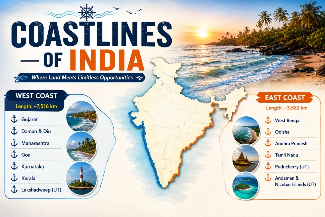
India’s coastline stretches approximately 7,516.6 km across the mainland and islands. The Indian coastlines are covered by the Arabian Sea, the Bay of Bengal and the Indian Ocean and are typically divided among eastern coastlines and western coastlines. The western coastline has nearly submerged into the sea which makes it very close to nature, and it includes the Kutch and Kathiawar Peninsula, Konkan Coast, Kanara Coast and Malabar Coast. On the other hand, the eastern coast is flat plain land which consist of Utkal Plain, coromandel, river deltas and Sundarbans delta.
What are Coastlines?
A coastline is a boundary line where land meets a large body of water which is generally such an ocean, sea and gulf. It is a constantly shifting zone rather than being in a fixed line. Coastlines are shaped daily by waves, tides and different weather conditions. Depending on the region, it can consist of sandy beaches, steep rocky cliffs, mudflats and river deltas. India has a coastline of 7,516.6 km, comprising 5,422 km along the mainland and 2,094 km across island territories. Bordered by the Arabian Sea, the Bay of Bengal and the Indian Ocean, this extensive maritime boundary supports diverse ecosystems, major ports and crucial economic activities across 9 coastal states and 4 Union Territories.
Length of Indian Coastlines
The total length of the Indian coastline is 7,516.6 km, as verified by the Ministry of Ports, Shipping and Waterways. This includes both the mainland and India's island territories. The mainland coastline extends for 5,422.6 km across the coastal states and Union Territories, while the island coastline covers 2,094 km across the Andaman and Nicobar Islands and the Lakshadweep Islands in the Arabian Sea. Similar to archipelagic regions such as the Solomon Islands, India's island territories play a crucial role in enhancing maritime connectivity, biodiversity, and strategic significance.
Coastal States of India
India has 9 coastal states such as West Bengal, Andhra Pradesh, Gujarat, Maharashtra and Puducherry and 4 coastal Union Territories such as Lakshadweep and Puducherry. The states and territories are geographically organized into the Western Coast which borders the Arabian Sea and the Eastern Coast which borders the Bay of Bengal. Let’s take a look at the coastal states of India: -
Western Coastal States and Union Territories
The western coastal states are generally narrower and submerged coasts which provide excellent conditions for natural deep-water ports. Some of these states are Gujarat, Maharashtra, Karnataka and Kerala. Let’s take a look at the western coastal states and union territories: -
| S. No. |
State/Union Territory |
Capital |
Coastline Along |
Coastline Length |
| 1 |
Gujarat |
Gandhinagar |
Arabian Sea |
1,600 km |
| 2 |
Maharashtra |
Mumbai |
Arabian Sea |
720 km |
| 3 |
Goa |
Panaji |
Arabian Sea |
100 km |
| 4 |
Karnataka |
Bengaluru |
Arabian Sea |
300 km |
| 5 |
Kerala |
Thiruvananthapuram |
Arabian Sea |
580 km |
| 6 |
Dadra and Nagar Haveli and Daman and Diu |
Daman |
Arabian Sea |
40 km |
| 7 |
Lakshadweep |
Kavaratti |
Arabian Sea |
Island Territory |
Eastern Coastal States and Union Territories
The eastern coastal states and Union Territories consist of fertile plain lands and is home to the largest mangrove forest known as the Sundarbans Delta. Some of these states are West Bengal, Odisha, Andhra Pradesh, Tamil Nadu and Puducherry. Let’s take a look at the eastern coastal states and Union territories: -
| S. No. |
State/Union Territory |
Capital |
Coastline Along |
Coastline Length |
| 1 |
West Bengal |
Kolkata |
Bay of Bengal |
150 km |
| 2 |
Odisha |
Bhubaneswar |
Bay of Bengal |
480 km |
| 3 |
Andhra Pradesh |
Amaravati |
Bay of Bengal |
970 km |
| 4 |
Tamil Nadu |
Chennai |
Bay of Bengal |
1,075 km |
| 5 |
Puducherry |
Puducherry |
Bay of Bengal |
45 km |
Features of the Coastlines of India
The Indian coastline is broadly classified into two categories such as the Western Coastal lines which is a narrow strip of land connecting the Arabian Sea and the Eastern Coastal lines which is a flat plain land connecting the Bay of Bengal. Let’s take a look at the features of the coastlines of India: -
The Western Coastal Lines
The Western Coast is a narrow strip of land between the Arabian Sea and the Western Ghats. It is a submerged coastline and consist of Konkan Coast, Kanara Coast, Malabar Coast, Kathiawar Peninsula: -
- Kutch and Kathiawar Peninsula: The Kutch and Kathiawar Peninsula is located in Gujarat, and this area has unique salt marshes of the Great Rann of Kutch. It contains deep gulfs such as the Gulf of Kutch and the Gulf of Khambhat.
- Konkan Coast: The Konkan Coast stretches from Daman and Diu down to Goa. This region is highly rugged and rocky and is characterized by cliffs, caves and sandy beaches.
- Kanara Coast: Kanara Coast spans across the state of Karnataka and this region are famous for spice plantations, pristine beaches and rich culture.
- Malabar Coast: Malabar Coast extends across Kerala to Kanyakumari, and this section is famous for its backwaters and lagoons. These unique formations run parallel to the shore and act as vital channels for fishing and transport.
The Eastern Coastal Lines
The eastern coast is a broad and flat plain land located between the Eastern Ghats and the Bay of Bengal. It stretches from the Krishna river delta down to Kanyakumari in Tamil Nadu. Let’s take a look at the eastern coastal lines: -
- Utkal Plain/Northern Circars: The Utkal plains is the northern stretch that covers coastal Odisha and parts of Andhra Pradesh. It features massive and shallow lagoons such as the Chilika Lake.
- Coromandel Coast: Coromandel Coast stretches from the Krishna river delta down to Kanyakumari in Tamil Nadu. Unlike the west coast, it receives a significant amount of rainfall during the winter from the northeast monsoon.
- Massive River Deltas: The river deltas have rivers flowing from the east such as the Godavari and Krishna which travel long distances across flat plains. They dump these sediments at the coast which creates expansive and highly fertile agricultural deltas.
- The Sundarbans Delta: The Sundarbans Delta is located at the northernmost tip in West Bengal. It is the world's largest mangrove forest, and it serves as an important ecological barrier against tidal surges and is home to the Bengal tiger.
Significance of Coastlines of India
The coastlines of India have enormous significance such as global commerce, salt production, oil and mineral deposits and biodiversity hotspots. Coastlines have natural defences such as mangrove forests which save the place from tropical cyclones, storm surges, tsunamis and soil erosion. Let’s take a look at the significance of the coastlines of India: -
1. Global Commerce
The coastline hosts 13 major ports such as Jawaharlal Nehru Port in Maharashtra and Chennai Port in Tamil Nadu. It is home to nearly 200 minor ports which handle over 90% of India's international trade and boosts global commerce.
2. Oil and Mineral Deposits
The coastlines have massive oil and mineral deposits such as petroleum and natural gas reserves. The place also has heavy mineral sands rich in ilmenite and monazite which makes it vital for the country’s energy security.
3. Salt Production
India is one of the top 3 global salt producers in the world. The coastlines help with salt production as they are connected to the Arabian Sea, Indian Ocean and Bay of Bengal. The vast coastlines help with easy loading and transporting of salt, supporting surplus export.
4. Biodiversity Hotspots
The coastal plains are rich with ecosystems such as estuaries, lagoons and coral reefs. It acts as a crucial habitat for marine flora and fauna which are nowhere to be found on Earth. The Lakshadweep Islands are home to coral reefs, seagrass meadows and endangered marine mammals such as the Dugong.
5. Natural Defenses
The eastern coastlines are home to mangrove forests such as the Sundarbans which act as natural barriers, dissipating the destructive energy of tsunamis, storm surges and tropical cyclones while preventing soil erosion. While the western ghat’s mountain ranges act as a barrier towards the land.
Conclusion
The Coastlines of India are 7,516.6 km in size and stretches along with the eastern and western ghats. Therefore, the coastlines are divided in two categories known as the western coastline and the eastern coastline. They have enormous significance such as supporting global commerce, salt production, being home to biodiversity hotspots and acting as natural defences against disasters. The western coastline includes states such as Gujarat, Maharashtra, Kerala and Karnataka. Whereas the eastern coastline includes states such as West Bengal, Odisha, Andhra Pradesh and Tamil Nadu.