NISAR is a $1.5B satellite landmark mission by the NASA-ISRO and is one that promises state-of-the-art radar technology to monitor global climate, respond to disasters, and provide science that is open to the world.
The NASA-ISRO Synthetic Aperture Radar (NISAR) satellite is a game changer in global space collaboration, which combines the most sophisticated radar technology of the Americans with the well-established Indian capabilities in satellite design and making. With a mass of more than 3 tonnes and a cost that is1.5 billion USD, NISAR is the most costly Earth-observation mission that has ever been designed so far, which makes the degree of the scientific and strategic anticipation surrounding the expected success of the project out of scale. NISAR is designed to have a powerful radar device and have a high potential to image dynamic processes on Earth with high resolution and fast rates; its powerful back-to-back radar (L-band and S-band) payload is developed by NASA-Jet propulsion laboratories and ISRO-UR Rao satellite centre over an interceding timeframe of close to a decade. The satellite will have revolutionary applications in climate science, disaster resiliency and sustainable development by monitoring forest biomass levels, and glacier movement, detecting land subsidence, and crop patterns. Its information will be of open-access nature, making it possible to empower not only the world-leading research institutions but also the developing countries struggling with environmental issues. NISAR is not only a technological achievement, but also a sign of science diplomacy the benefits of which show that countries may treat international barriers as an opportunity to cooperate and solve problems on planetary scale. Still waiting to go into orbit, this article discusses what is so special about NISAR, and why it could provide a new way of looking at and protecting our dynamic planet.
Origins and Cooperation
The NISAR mission is not just an engineering marvel; it is a new direction in international scientific cooperation and planet management as it is made by a joint vision of two spacefaring countries over ten years.
The Seeds of Partnership
In 2012, NISAR was nitiated in the form of a joint vision between the Jet Propulsion Laboratory (JPL) of the NASA and the UR Rao Satellite Centre (URSC) of ISRO. The concept was audacious: combine the accuracy of the American L-band radar with the nimbleness of the Indian S-band radar in order to measure the motions of the planet at a shot. These two agencies took a pledge to establish the first ever dual-frequency earth observing ground breaking radar satellite by capitalizing strengths of the two agencies to have a NASA legacy in synthetic aperture radar and low cost innovative satellite production at ISRO.
Shared Objectives
Besides technological hubris, NISAR is a statement of Science without Borders. This cooperation is in line with the increasing strategic and diplomatic relations between the United States and India, which include climate resilience and sustainable development. Its philosophy of open data signifies this inclusiveness of the mission that is the availability of datasets free of charge by global researchers, civil authorities, and policy formulators.
Synergy and Co-Development of Institutions
Smooth co-development is pictured in the hardware division: NASA supplied L-band radar system, high power electronics and the large deployable antenna; ISRO contributed the satellite bus, launch vehicle (GSLV) and S-band radar. This is a joint architecture, as it was crucial that both agencies did not just share their learned knowledge, but also their financial, operational and logistical affairs.
Technical Wonders of NISAR
NISAR is not just an Earth observation satellite, but a combination of first-of-kind radar technology and space engineering expertise as well as data systems that have never been operationally deployed in low-Earth orbit at scale.
Dual-Frequency SAR
NISAR will center on a Synthetic Aperture Radar (SAR) that will run on two different frequencies; the L-band developed by NASA that will penetrate through dense vegetation and ice, where S-band developed by ISRO will only detect minute surface deformation. This bi-modal mode allows the mapping of forests, glaciers and fault lines in parallel and with frequency unheard of in studies of the geophysical processes on our earth, adding many layers of understanding.
SweepSAR and Wide-Swath Imaging
SweepSAR, which is a new mode of SAR, enables the satellite to have a 240 kilometres swath and the resolution of up to 3 to 10 meters. This tradeoff guarantees fast, frequent acquisition of dynamic terrains: tectonic plates, flood zones, etc. which are important to monitor disasters and analyze climate change.
ADeployable Gold Mesh Antenna
The most memorable aspect of it would be that NISAR will have a 12-meter unfurlable antenna whose construction is of gold-plated wire mesh. When launched into space, it will be the most extensive SAR reflector ever put into space, as it allows scanning satellitesignals without problems with their acquisition, mass-minimized, and an engineering achievement which combines dimensions, materials, and accuracy.
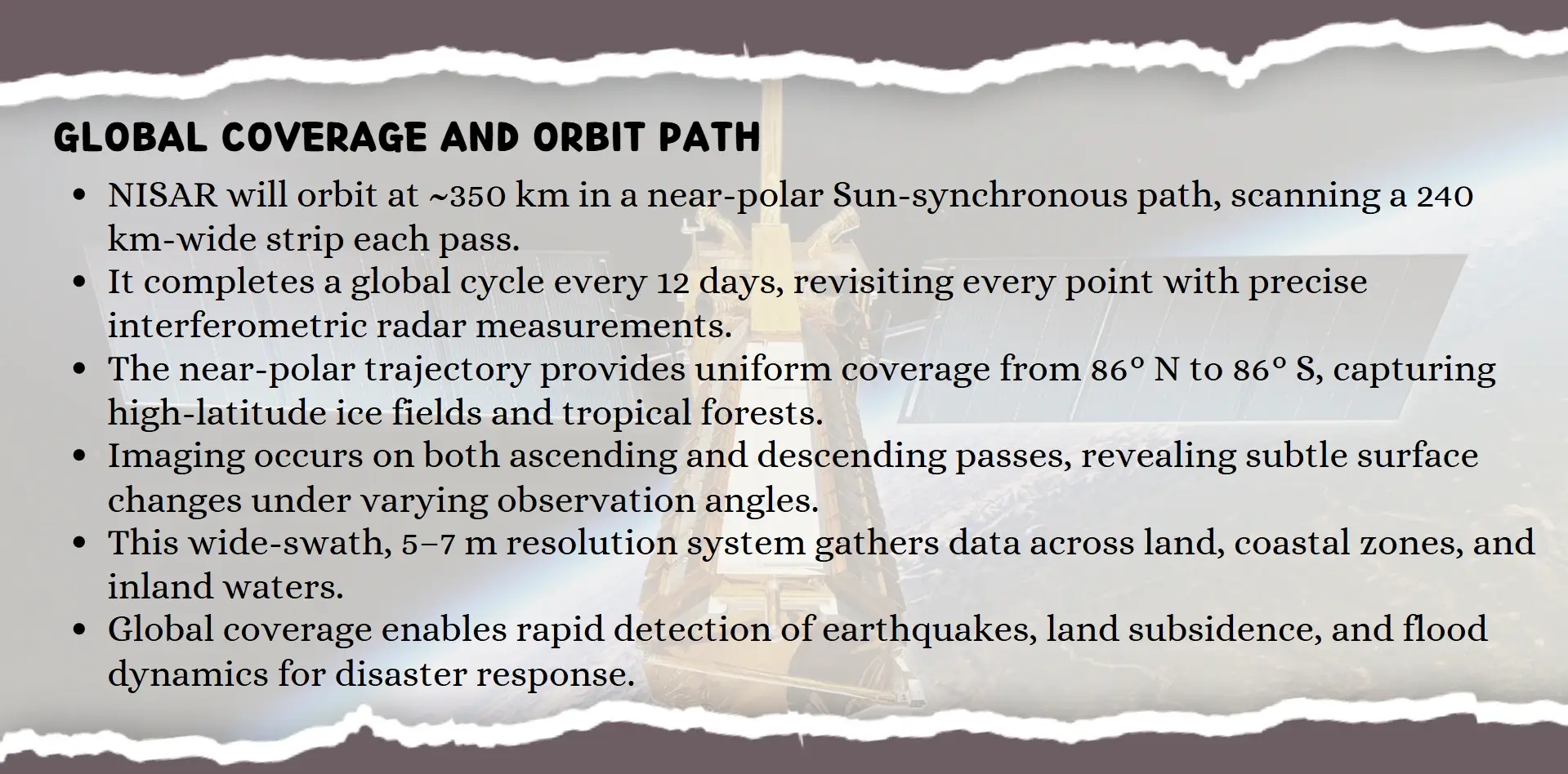
Orbital Mechanics and Coverage Strategy
NISAR will have a sun-synchronous orbit of about 747 km that will span a 98.4 degree inclination. This orbit provides consistent imaging lighting conditions, with global revisit times of every 12 days, which is perfect to monitor seasonal changes and short-term processes such as landslides, crop stress, etc.
Technical abilities and applications in science
NISAR has its revolutionary radar systems and rapid revisit time, changing the perception of scientists having a dynamic picture of the planet, providing real-time actionable information to maximize resilience to climate change, sustainability and disaster risk reduction.
Environmental Surveillance
The NISAR dual-frequency radar is useful in coming through thick vegetation and therefore, it is excellent radar in tracking forest changes and deforestation. This helps in international carbon accounting initiatives and biodiversity protection goals under the UN REDD+ process. A highly valuable attribute is wetland mapping, with its ability to sense seasonal changes in the extent of coverage by water and vegetation, and to monitor environmental health of habitats that harbour migratory species and may be used in policy making decisions relating to land use.
Monitoring of Climate Science and Cryosphere
The ability of the satellite to capture glaciers and ice sheets with a high level of accuracy makes it possible to capture the rate of melt in Greenland, Antarctica, and Himalaya. These measurements fed intoglobal sea level rise models and climate predictions. Also, NISAR will be able to sense permafrostthaw a growing climate hazard through gradual change in ground movements related to destabilization in polar areas.
Natural Hazards and Disaster Preparedness
Earthquakes, volcanoes, landslides and glacial lake outburst floods (GLOFs) are rapidly occurring and devastating. NISAR has the ability to identify small movements of the ground before such activities take place days or weeks later. This advance warning capability is invaluable in vulnerable regions in Southeast Asia, the Pacific Ring of Fire and the Andes that will enable the local governments put in place precautionary measures.
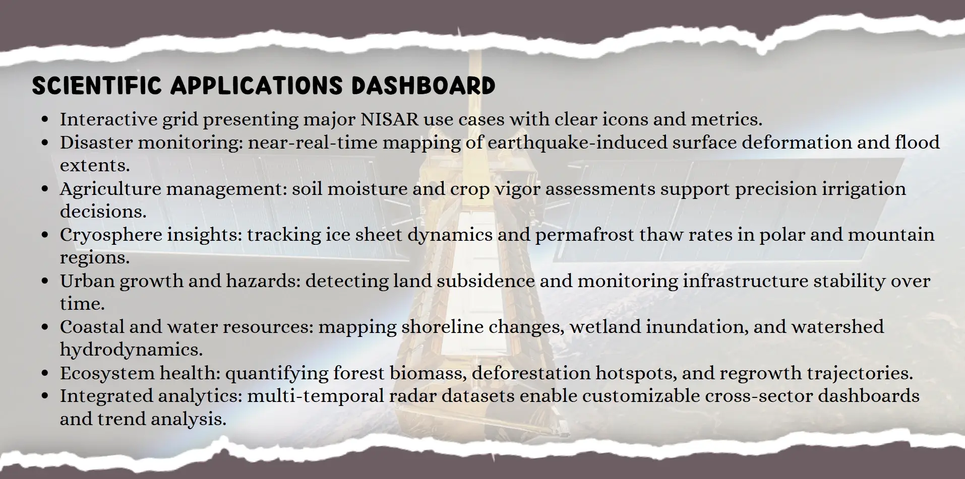
Food Security and Agricultural Planning
NISAR provides accurate information that enables crop prediction and the management of water resources by mapping the conditions of the soil based on the moisture levels, plant health, and irrigation schedules. The news can be stabilizing in food supply chains and decision-making regarding whether to invest in climate-smart farming, in countries reliant on rainfall as the source of agricultural production.
Urban infrastructure and risk management
The fast city sprawl has its dark side, the land sinks in, the dams and bridges get stressed out and then we also have the depletion of ground water. The radar interferometry of NISAR is able to measure millimetre changes in infrastructure as it occurs over time. City planners and engineers will have an instrument to measure vulnerability and enhance building codes and work out city resilience strategies.
Democratizing Data to Global Science
In contrast to most other high-cost observation platforms, NISAR is an open-access platform. Data will be analyzed and made accessible to the world of scientists in a matter of hours. This democratization comfortably enables everyone to participate in the research process and enables developing nations to utilize the advanced geospatial data to develop friendly policies to adapt to the changes and establish a sustainable ecosystem in terms of cost free investment.
Global and Strategic Influence
In addition to its scientific value, NISAR is much more than a technological breakthrough in space relations, climate management, and data equity around the world, as it changes how states agree to operate.
Science Diplomacy and Bilateral Trust
The NISAR mission is landmark collaboration between Indo-US in the field of space technology. It is a culmination of ten-year collaboration between ISRO and NASA, with both democracies sharing a fixation on climate action and technological advancement. This successful launch on GSLV-F16 is the first ever satellite to be put in sun-synchronous orbit and the reason that makes this particular launch significant is that this is the first stem of building trust between the two giants.
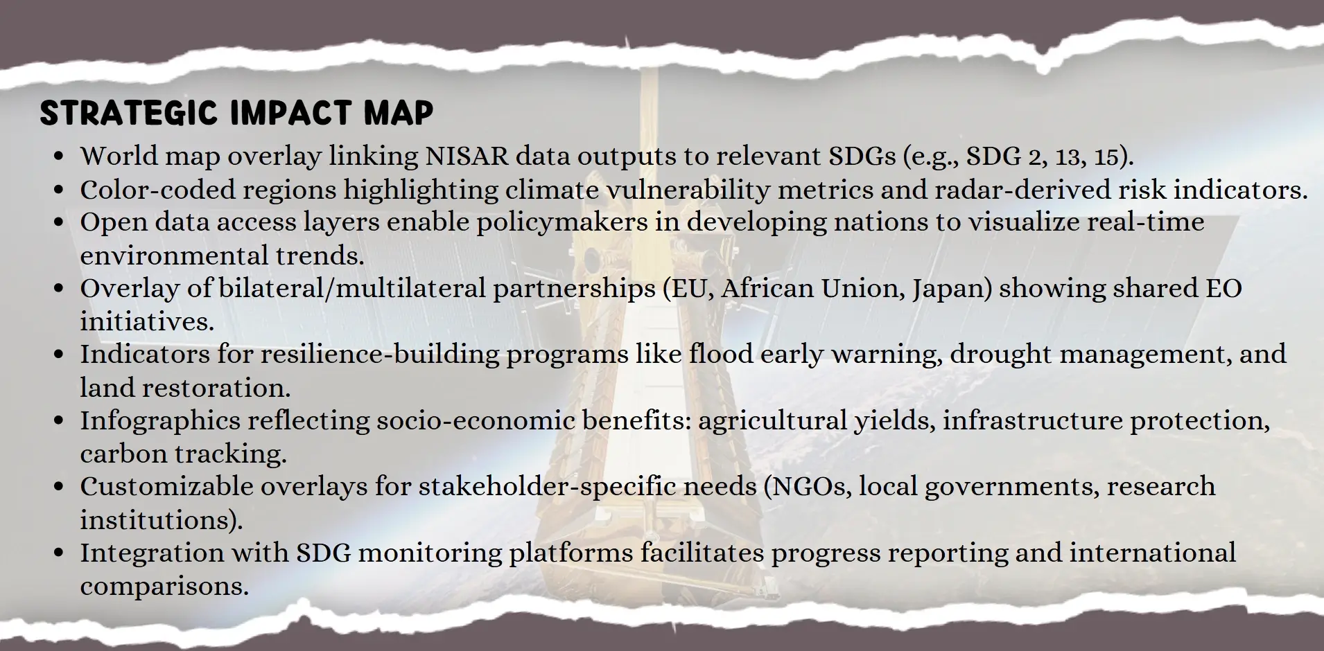
International Climatic Leadership and Policy Relevance
The potential of NISAR to provide near real-time high-resolution land deformation, glacial melt, and soil moisture data makes it an evidenced-based policydevice at the global climate and disaster preparedness levels. It provides free of cost access to up to date geospatial intelligence because its open-access model democratizes Earth observation and enables developing countries to access the most up to date geospatial intelligence without the financial cost. This contributes to global systems such as the UN Sustainable Development Goals (SDGs), particularly on the dimensions of climate resilience, food security and sustainability of cities.
The Model of Future Multilateral Missions
NISAR brings together dual-frequency radar systems of two space agencies, creating a precedent to be used to design future multinational satellite missions. Its success can stimulate partnerships with the EU or Japan or African space systems or programs-heralding an age of collaborative earth science. The technical complexity and system of governance indicative of the mission itself depicts that scientific ambitions can overcome geographic boundaries and create a more inclusive and responsive global space environment.
Difficulties and Perspective
There are challenges that will determine the success of NISAR including technical, operation, and strategic issues that will define the dynamics of space partnership and missions in the future.
Complication and Integration Problems
The coordination of the dual-frequency SAR system reduction of NASA L-band with the ISRO S-bands rendition was unheard-of engineering assembly. Maintaining a smooth calibration, signal synchronization and deployment of antennas required huge amount of design and testing efforts. The 12-meter gold mesh antenna as the biggest one was the one that had to be folded and revealed with millimetres precision as any malfunction could prove to be the death of imaging quality or even mission effectiveness.
Data Volume and Data Processing Infrastructure
NISAR will create approximately 80 terabytes of data per day, so the necessary infrastructure should include strong cloud-based settings where the data can be stored, calculated, and distributed. It is logistically challenging to deal with this data deluge and keep it ready to be accessed and remain scientifically pure at the same time. How to provide equal availability in different countries and institutions particularly the bandwidth limited places is a main operational challenge.
Sustainability and Long Run Value
NISAR has a design life of five years and its legacy will be determined by the continued funding, satellite health, and user requirements. More future missions might demand more radar capability, the integration of multispectral or AI-based analytics as the dynamic of climate hastens. Successor missions or modular upgrades will need to be planned to be relevant, and to provide continuity.
Possibility of Multilateral extension
The success of project preconditions cooperation on a larger scale on an international level. Europe, Japan, and Africaagencies can soon participate in radar activities and share the facilities to cover the entire globe. The open-data, co-development culture of the mission is an instructive example of the new, inclusive nature of science-based diplomacy, in which common technology is expanded in the interests of the planet.
Conclusion
The NISAR is a milestone in terms of observation of the earth and cooperation. It combines the dual-frequency radar with wide-swath imaging and rapid revisit, which makes it one of the leaders in climate science, disaster resilience, and sustainable development. However NISAR is also about more than hardware, about the audacious spirit of cooperation resulting in a transgression of geopolitical boundaries in the name of stewardship of our planet. Making high-resolution environmental data available to as many people as possible makes the mission democratic and provides more countries with the means to deal with ecological threats with accuracy and foresight. NISAR is not only an indicator of an emerging space diplomacy, but it is also a demonstration that international cooperation is the way to tackle global challenges, and the answer can be knowledge that is common. By changing the way we look at our planet, it revamps the way we work to preserve it as well. NISAR is not only a satellite; it is an expression of possibilities when science and solidarity act in space.