A hurricane named Erin has caused hazardous surf and rip currents along the east coast of the United States and is a reminder of the climate threat and coastal risk.
Hurricane Erin, churning insidiously northeast of the Bahamas, is already having its effect along the East Coast of the United States. Although the storm is not expected to reach land, it is causing waves that could have potentially fatal surf and rip currents in locations as far north as Massachusetts. This is an increasing truth because hurricanes do not have to fall directly to cause havoc. Erin is on a path that is predicted to be northward and subsequently north-eastward, a position that places it in proximity with heavily-populated coastal areas where delicate infrastructure and crumbling coasts increase the risk.Over the past few years, the East Coast has been overwhelmed with climate-induced potential coastal hazards more intense systems of storms, rising sea levels, and other tidal fluctuations. Hurricane Erin is one indicator of this new normal wherein even remote cyclones that find their way offshore could impact tourism, threaten swimmers, and overstretch emergency response capabilities. This article examines the meteorological characteristics of the case of Erin and its second-hand effects and the overall implications of coastal resilience in the age of emergent climate extremity. Using scientific analysis, policy perspectives, and real-time data, we look at how modern preparedness, communication, and infrastructure must change to address challenges of storms that strike far away.
Meteorologicalprofile of Hurricane Erin
Hurricane Erin the first major storm of the 2025 Atlantic season, and it has grown by leaps and bounds to form a formidable system. The severity and course of its passage though may also require intensive meteorological study even though it is off any shore in the world and needs attention by the people.
Formation and Early Development
Erin originatedfrom an African easterly wave that originated along the west coast of Africa on the 9thof August. By August 11, it had formed into a tropical storm on the eastern Atlantic, becauseof well-defined low-pressure center and 45 mph of sustained wind. Erin was initially hampered by dry air and marginal sea surface temperatures, and as such was a weak system as it moved westward across the central Atlantic.
High Rates of Increase and Maximum Power
On August 15, Erin transitioned to a hurricane with gales that sustained 75 miles perhour. Less than 24 hours later, it experienced extremely rapid intensification by moving up the scale to an intense hurricane Category 5 with hurricane speeds of 160 miles per hour. This increase in speed over 85 mph highly surpassed the criterion of rapid intensification of 35 mph, positioning Erin on the list of the most severely upgrading hurricanes in the last several decades. This led to the explosive growth of favourable conditions that included low wind shear and warm ocean temperatures (which rose to 84 F, up from 81F).
Structural transformation and Size growth
After reaching its maximum, the eye became an eyewallreplacement cycle in which the inner eyewall is replaced in favour of a new outer eyewall, further weakening the system, but increasing the radius. This caused a reduction to Category 3 and it later re-intensified to Category 4 before being stabilized in Category 2 owing to vertically augmented wind shear. Erin had a broad wind field but fluctuated greatly in its strength, even as it sustained hurricane-force winds out to 25 miles and tropical-storm-force winds extending 115 miles.
Hurricane and its types
With its powerful winds, rain, and low air pressure, a hurricane creates a destructive tropical cyclone. These are storms that develop over warm sea water and can be disastrous all over coastal territories.
Definition and Structure
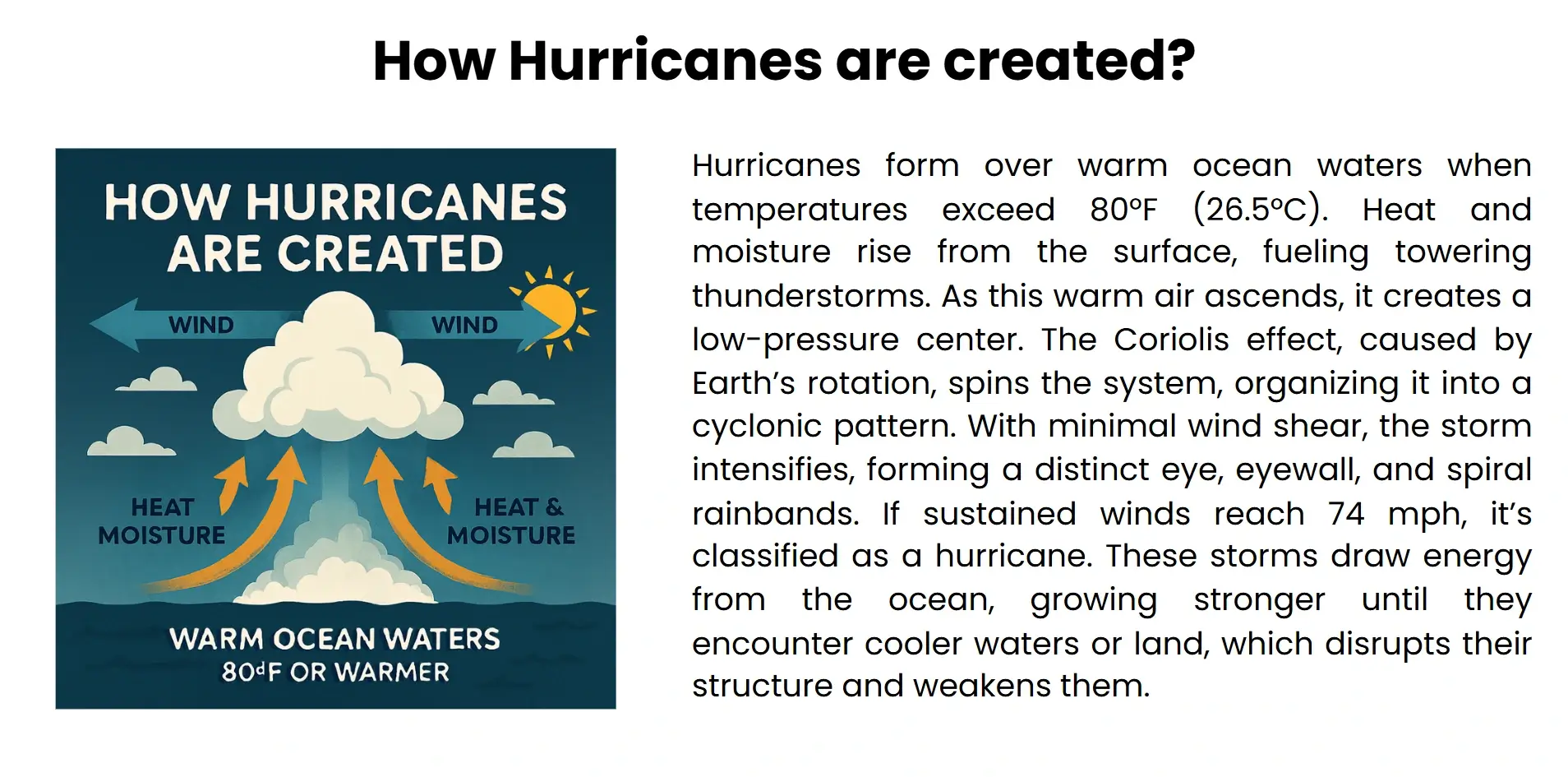
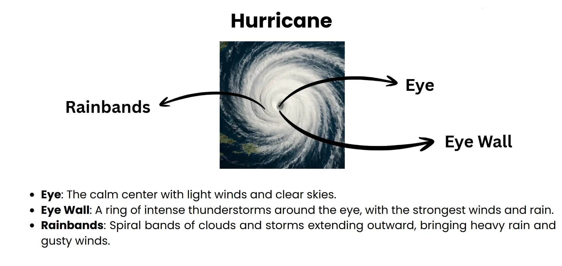
Hurricanes are spinning low webs in which storms form in the tropics or sub-tropics. When wind speeds surpass 74 mph, they are classified as tropical cyclones. The eye, which is a calm center, the eyewall, which is a zone of the strongest wind and rain intrusion, and spiral rainbands that radiate outward are the three main parts of a normal hurricane. Categories mode of hurricane is defined as Category 1 (lowest) to Category 5 (highest) according to the wind speed in terms of the Saffir-Simpson scale.
The Major factorsof Formation
Three main conditions are vital to energetic development of hurricanes:
- Warmer ocean water (above 26°C or 78.8°F)is the source of heat.
- The storm's latent heat is created when the moist, unstable air condenses as it rises.
- Low vertical windshear can enable the occurrence to reach it’s organizational and strength potential without being disrupted.
The fact that the earth rotation introduces the Coriolis effect that gives the system a spin thus allowing it to move cyclonically. When the warm air cools, it produces a self-propelling loop that makes the storm core more intense and increases its radius.
Knowing about hurricanes is crucial in regard to creating resilience and disaster preparedness. With rising temperatures in the ocean, frequency and intensity of these storms is likely to intensify creating more dangers due to vulnerable people present in coastal areas.
Coastal Impacts without Landfall
As it rages over a distance 60 miles offshore, Hurricane Erin is causing substantial problems in the United States East Coast in total proving how an offshore storm can still bring a lot of risks to human life and property.
Dangerous Surf and Rip Currents
Erin has such a big windfield that it is creating large ocean swells of up to 20 feet off the Outer Banks of North Carolina and 8-10 feet along the Atlantic coast of Florida. These waves are causing life threatening rip current off Miami to Maine forcing mass beach closures and no-swim advisories in states such as New Jersey, Delaware, and North Carolina. Rescue missions have gone through the roof with more than 75 positive incidences having been noticed in Wrightsville beach.
Erosion and risk of flooding
The outer bands of storm are causing a storm surge of 2-4 feet making low-lying coastal areas flooded and increasing beach erosion. The combination of high tides with high sea levels (currently some 6 inches higher than in prior decades) is now finding its way further up the beaches, eroding sand and natural protection. Such wear is especially intense in barrier island communities where infrastructure is already vulnerable.
Road Safety and Evacuations
Even though Erin is still several hundred miles out in the ocean, some areas of North Carolina have declared states of emergency and tens of thousands of people in the Outer Banks have been evacuated. Meteorologists note that deceptive quiet weather could tempt the most vigilant swimmers into irreversible harm as it is no longer accurate that the closer one gets to the eye, the safer they are.
Climate Change and Coastline Exposure
The offshore effects of Hurricane Erin and its intensification are quite a grim indicator of the changes that are taking place in coastal risk profiles owing to climate change.
- Warmer ocean temperatures by up to 1.1C beyond historical levels have caused the rapid intensification of storms such as Erin to become up to 100 times more probable, in a Climate Central analysis of its path.
- Not only does this warming contribute to more destructive hurricanes, but it also extends their power further down the coast as strong waves and storm surges spread to coastlines even where there is no landfall.
- The rise in sea compounds the threat Along the East Coast of the United States, the average sea level was raised by about 7 inches since 1970, but it is estimated that between 1970 and 2050 it is expected to be increased to 10-14 inches.
- This elevation makes storm surges and high tides more easily infiltrate inland, stripping away dunes, flooding roads and destroying infrastructure. Barrier islands such as Hatteras are particularly susceptible and relatively low- experienced surges can cut escape routes and isolate whole communities.
- Human modifications likeseawalls and levees often aggravate the situation by hampering the flow of sediment and increasing the effects of erosion during major storms. As Erin demonstrates that now, it is not only hurricanes themselves that are becoming worse, but the indirect effects as well. Resilience in the coastal environment has to be resilient, nature-basedandclimate-adaptive to protect lives and livelihoods.
How the naming of Hurricaneis done?
Names are given as a tool used to simplify communication and to avoid confusion when monitoring the storms, especially where there are multiple storms in existence.
- The naming is done under the coordination of the World Meteorological Organization (WMO) that carries six lists of names in succession, one for each of the basins. The names are repeated 6 years after they were first published and listed in alphabetical order and alternating by gender to create a balance and a sense of clarity.
- A tropical storm is also given an official name when it reaches winds to 39 mph (63 km/h). When it increases to reach another level of 74 mph or beyond it becomes a hurricane that carries on the same name. Due to a lack of names, storms are given names that start with the letter A, followed by the letter B, and so on. The letters Q, U, X, Y, and Z are not used.
- Names are chosen to be shorter, culturally orienting, and simple to say whether in different languages or not. In the event of hurricane causing massive destruction or loss of lives, the name is discarded permanently in remembrance of those people who lost their lives. As an example, Katrina, Harvey and Ian have been retired and new entries have replaced them.
This system facilitates effective communication of warnings to the population, media coverage and emergency response without which, storm names would only be used as mere nomenclature.
Preparedness and Response Policy
In response to the intensification of Hurricane Erin offshore, agency of emergency management throughout the east coast of the United States were quick to minimize the effects of this hurricane, which despite being indirect, were hazardous.
- Despite the storm's continued presence at sea, state-level emergency declarations have been prompted by its powerful surf and rip currents. In North Carolina, for example, the governor ordered the State Emergency Response Team to be activated, placing swift water rescue units, National Guard forces, and aircraft.
- Local authorities called out compulsory evacuations in at-risk areas like in Hyde and Dare Counties and ferry services were utilized to transport nearly 2,000 people off barrier islands such as Ocracoke. Emergency shelters were made with pet accommodations and infrastructure crews hardened dunes and other flood-prone areas such as NC-12 to prevent over-wash damage.
- In the British Virgin Islands, drainage clearing and district response teams which were set up in advance of the storm assisted in preventing damage, although Erin passed further north at Category 5 intensity. The operational readiness of the event was reported to have improved by 85 percent with some districts not only contributing zero cost intervention but also partnering with the community.
These responses point to the changing process of hurricane preparedness where storms at sea require on-land preparation, minute-to-minute strategizing, and climate resilient infrastructure. The situation of Erin lends added importance to comprehensive disaster planning that takes into consideration both the frontal and the peripheral dangers of a storm.
Conclusion
The out to sea trajectory of Hurricane Erin is forecast to miss hitting the U.S. East Coast directly, yet its effects are not harmless. Dangerous rip currents and beach erosion, emergency evacuation and strain on infrastructure, all illustrate recent changes in the risks faced by tropical cyclones in the warmer world. With the changing climate intensifying the storm behaviour and raising the sea level, even remotely-generated hurricanes can lead to the cascade of threats in coastal communities.This hurricane is a reminder to policy makers, scientists and residents that preparedness should be after the eye of the storm. An integrated approach to coastal management, climate-adaptive infrastructure development, and development of awareness campaigns are not an option anymore ratherit is a necessity. Erin will not be measured by where it lands, but by the way we improve the boundaries of risk that it helps us see. Resilience starts with realizing that proximity is no longer the only indicator of danger in a time of rising seas and changing storm patterns.