|
Key Highlights
- Changing Weather patterns in Northern India
- Western Disturbances
- Arabian Sea Moisture drift
- Compound weather events
- Limitations in Forecasting
- Need for Policy reforms
- La Niña and El Niño
|
The article discusses the effect of abnormal western winds, along with peculiar trends in Arabian Sea wind variations during monsoon, on the inactivation of extreme rains in North India.
|
Tips for Aspirants
The article will be useful to the aspiring students of the Union Public Service Commission (UPSC) examination and other State Public Service Commission (PSC) candidates in that it correlates climate science to governance, disaster management, and policy formulation- some of the most common topics in the GS papers, essays, and interviews.
|
Relevant Suggestions for UPSC and State PCS Exam
Key Highlights
- Western Disturbances: a typical increase in the seasonal rainy conditions occurs during the monsoon months and complicates cloud bursts and flash floods in North India.
- Arabian Sea Moisture: usually northward Moisture-bearing winds typically found in the east arrive in the arid north for example, in Ladakh because of shifted jet streams and rising ocean surface temperatures.
- Compound Weather Events: Western disturbances and Monsoon systems interact to establish specific standards of rainfall extremes that require multi-hazards risk assessment.
- Rainfall Extremes: Punjab, Delhi, and Himachal Pradesh states experienced large amounts of rainfall portraying spatial uncertainties and time vulnerabilities.
- Climate Change Linkages: ENSO, La Nina, and intra-seasonal oscillations are believed to have effects on the transport of moisture and precipitation variation.
- Policy Implications: Calls for an active forecasting models, robust infrastructure, and combined disaster management models.
- Exam Relevance: GS Paper I (Geography), GS Paper III (Disaster Management, Climate Change), and Essay Paper.
- Interview Utility: demonstrates awareness about the climate-governance interconnectedness and regional uncertainties.
|
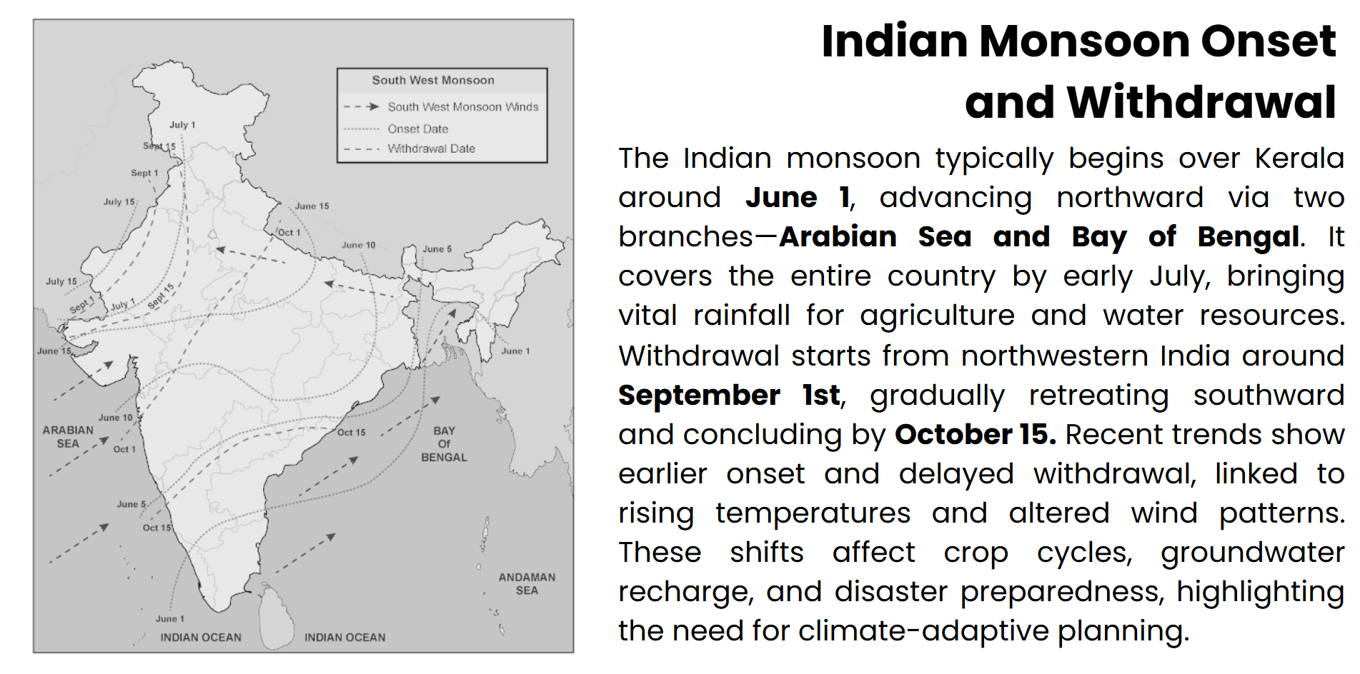
The Indian monsoon is a complicated and evolving climate phenomenon that has historically governed the agricultural seasons, water supply, and ecological equilibrium of the subcontinent. But recent years have brought about a disastrous increase in rainfall related disasters in North India like flash floods, landslides, and flooding of cities. This is more and more being blamed not necessarily just on the strength of the monsoon itself, but on the abnormal interaction of the regular systems of the season, and of unusual atmospheric upheavals. It is quite interesting to note that the frequency of western disturbances during the monsoon period has been very high, and this is during a season that usually occurs in winter, resulting in unstable and highly concentrated events of precipitation. At the same time, the strange northward movement of moisture laden winds around the Arabian Sea, which are usually aggravated by warming sea surface temperatures and distorted wind circulations, has also intensified the anomalies in rainfall. These two upheavals have resulted in an unsteady weather system, making the threat of severe weather scenarios even greater. The current Article critically analyzes these converging factors, considering its climatological basis, spatial-temporal manifestation, and the disaster preparedness as well as climate-resilient governance. The study will provide contributions to a more subtle conceptualization of the regional climate variability and adaptive strategies to changes in hydro-meteorological risks, by unpacking the changing dynamics of the rainfall regime in North India.
Change in North Indian Rain
There has been a significant change in the rainfall regime of North India, where there are ever more irregularities in the timing, intensity, and spatial distribution of the rain. Such changes are indicative of more profound climatic changes and require a scientific and policy response.
Altering the dynamics of the monsoon
In 2025, the southwest monsoon reached Kerala eight days before schedule, but it entered into a break stage shortly after, thereby interrupting its northwards movement. Not only does such patterns of onset and withdrawal change the amount of rainfall, but also the pattern of its distribution, with intense surge rains after which there are considerable dry intervals. This uncertainty affects agricultural planning and water resources management, particularly in rainfed areas.
Rise in Extreme precipitation
There has been an increase in high intensity rainfalls in North India, with most of them ending up in flash floods and landslides. Such phenomena are no longer limited to the foothills of the Himalayas but tend to hit cities such as Delhi and Chandigarh. The type of monsoonal rainfall has been exacerbated by a convergence of the western disturbances, which provide the combination of the two systems, producing short-lived but high intensity rainfall. An example is Punjab with a surplus of 53 percent of rains in the months of June-early September of 2025, and 52 percent excess in Delhi.
Spatial Imbalance and Regional Exposure
The distribution of rainfall in North India is distorted, with deluges in certain areas and shortages in other areas. Such instability with time is attributed to the shifting wind patterns, or alternation of jet streams, or domination of certain low-pressure systems. The steep gradient terrain of the Himalayas, with its sensitive ecology, is especially sensitive, with even moderate rainfall making immense impacts on its people in terms of landslides and river based floods.
Climate Change Implications
These changes can be attributed to climatic temperature changes that are experienced globally, such as a rise in sea levels, temperatures, and a change in the cyclic atmospheric movements. The effects of these changes have been emphasized by the rise in frequencies of western disturbances in cultivating months and the repositioning of moisture rich winds across the Arabian Sea into northward directions. These widespread upheavals of the system are forcing a reconsideration of hydrologic models and forecasts. The resilience to climate change in the long term should focus on combining climate-resilient infrastructure, region-associated agricultural planning, and improvements in the early warning system.
Western disturbances during Monsoon
Western disturbances are a traditional winter-based weather pattern that have in recent years, presented an uncharacteristic spurt during the Indian monsoon seasons. The movement of this amount has changed the nature of rainfall over North Indian significantly, and flood risks and predictability in the seasons have become challenging.
Nature and origin of western disturbances (WDs)
WDs are extra-tropical cyclonic processes that originate over the Mediterranean. These move eastward by Iran, Afghanistan, and Pakistan and eventually get into northern India. These systems usually occur around the same period (December to March), which injects winter rain and snow on the western Himalayas, which makes a difference in the Rabi crops and revitalizes the groundwater.
Unseasonal persistence during the month of Monsoon
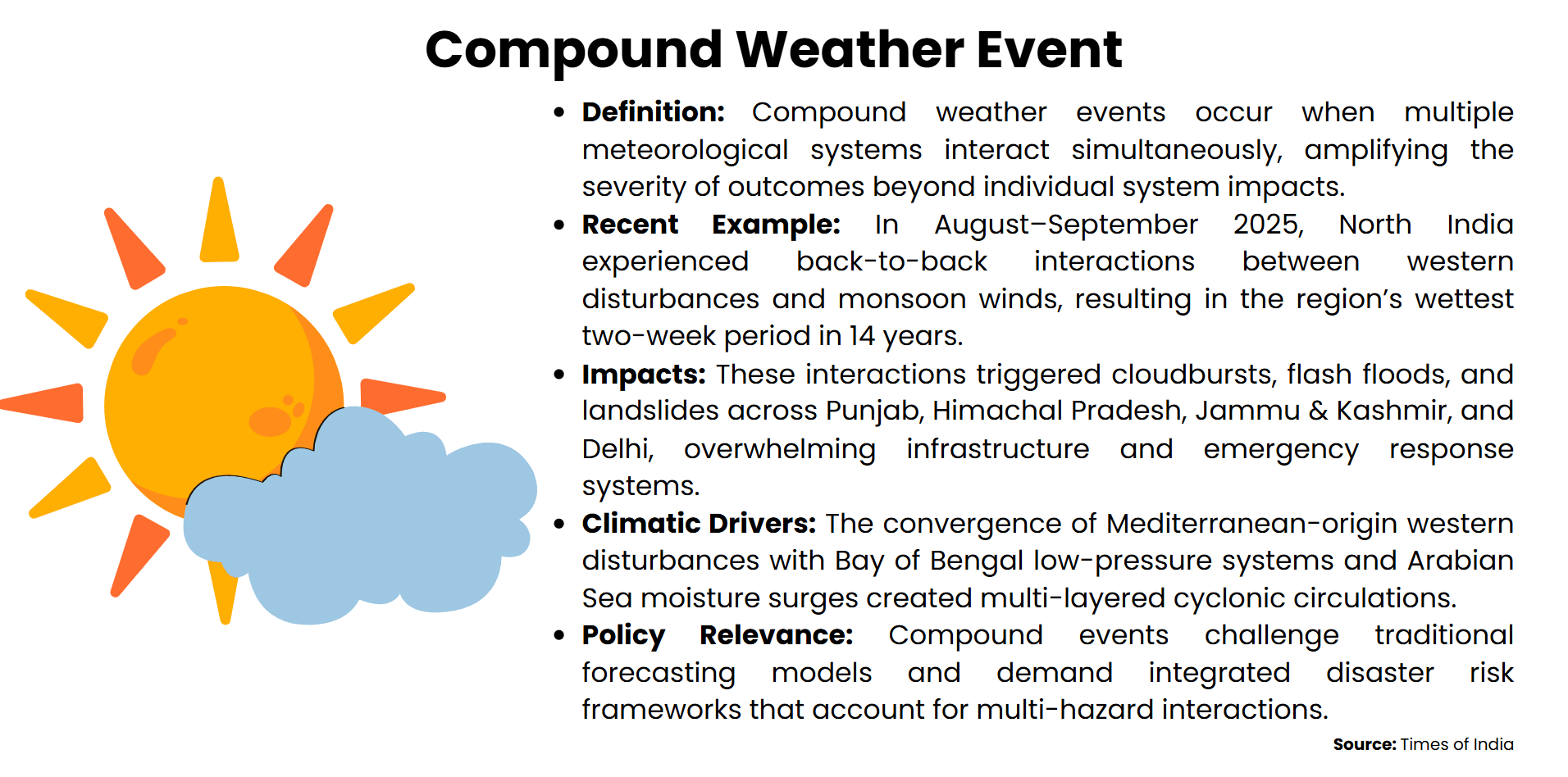
Newer meteorological information has shown that there has been a significant rise in the occurrences and intensity of western disturbances during the monsoon season (June-September). There were several inconveniences in 2025 that lasted long into the month of August, and they caused overlap with active monsoon stages. This intersection of systems, western disturbances, low-pressure areas in the Bay of Bengal, and influx of Arabian Sea moisture resulted in unstable weather situations that spawned very heavy rain in Punjab, Himachal Pradesh, and Delhi. The interactions are unusual and indicate a greater change in climate potentially attributed to global warming and a change in the jet stream pattern.
Amplification of Rainfall and Hazard Risk
The abnormal occurrence of western disturbances at the monsoon season has increased the intensity and spatial distribution of rain falls. Such systems cause mid-tropospheric cyclonic circulations that increase the surface convective activity, causing cloudbursts and flash floods. For example, Delhi and Ladakh recorded 52% and 444% excessprecipitation, respectively, in June-September 2025. Riverine flooding is another complication of the disturbances that synchronizes with monsoonal troughs to exceed the catchments and city drainage systems.
Forecasting and Climate Adaptation Implications
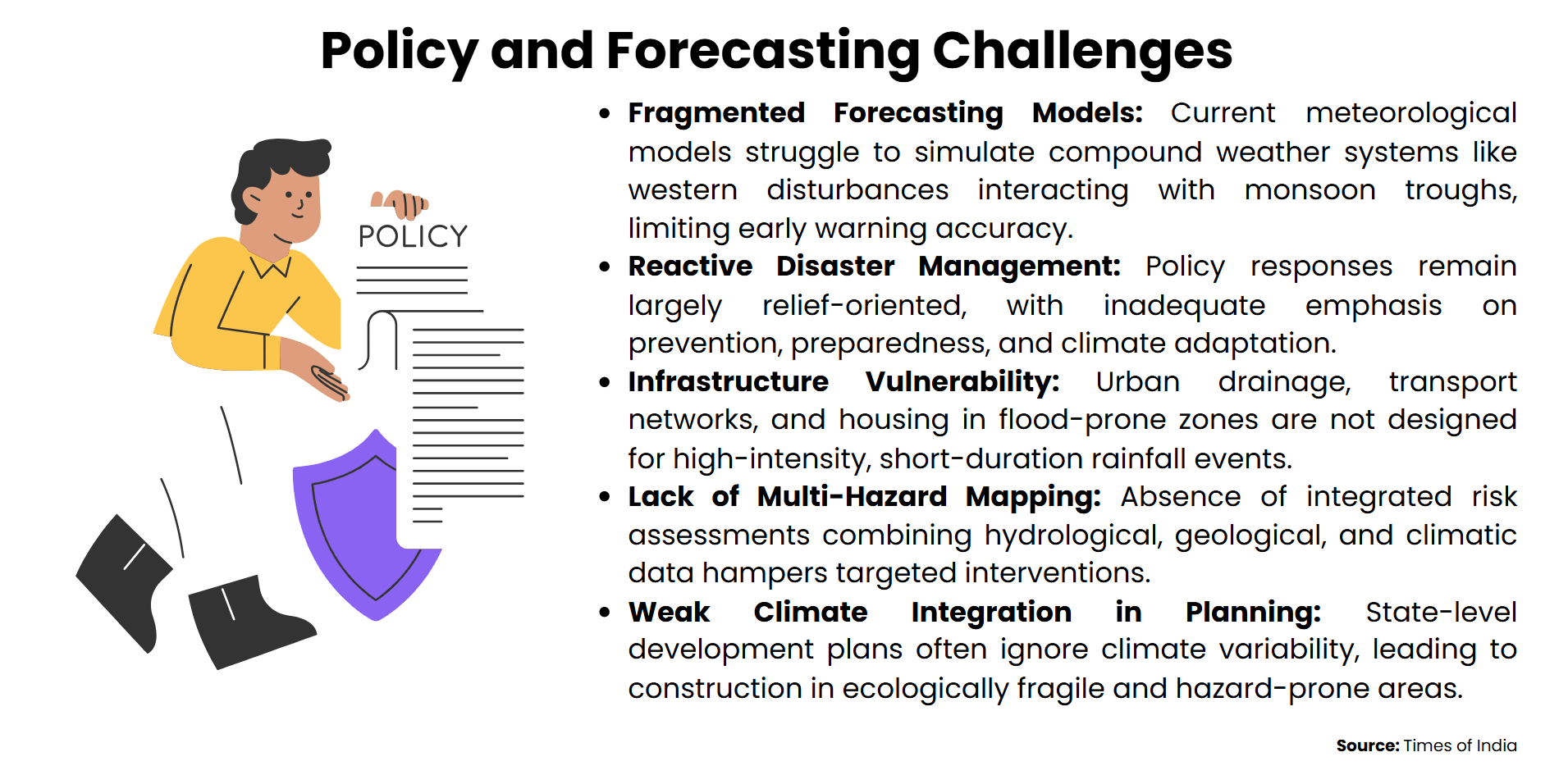
The western disturbances require a realignment of Indian weather forecast modelling due to the changing aspect of the behavior of these disturbances. Conventional seasonal barriers are becoming increasingly unclear, and forecasting technology should consider interrelations between systems. What is more important here is the enhanced satellite monitoring, active modeling, and area specific early warning systems. In addition, planning of infrastructure should incorporate such new rainfall realities so that climate resilient cities and agricultural systems can be established.
|
Basics
Western Disturbances: Climate Importance and Changing Effect
|
|
Western disturbances are extra-tropical cyclonic or tropical cyclonic in nature, and their formation begins in the Mediterranean and is carried eastward by the subtropical westerly jet stream. These low pressure systems move through Central Asia-through Iran, Afghanistan, and Pakistan to the northwestern section of the Indian subcontinent. The western disturbances, in contrast to the tropical monsoon systems, have moisture in the high troposphere and mostly occur during the winter months when they cause rainfall and snowfall to fall in the western Himalayas, Punjab, Haryana, and Delhi.
Their climate importance is that they maintain winter farming, especially the Rabi crops such as wheat, by becoming the providers of moisture to the soil, and also controlling the temperatures. But, over the past several years, there has been an anomalous rise in such disturbances, particularly in the monsoon season, resulting in compound rainfall events and increased flood dangers. This change is explained by the changes in the patterns of the jet stream and rise in surface sea temperatures that change the path and frequency of these systems.
Recognizing western disturbances is an essential dimension of climate-resilient planning, particularly in the domains of agriculture, water management, and disaster relief.
|
Arabian Sea Moisture Surge
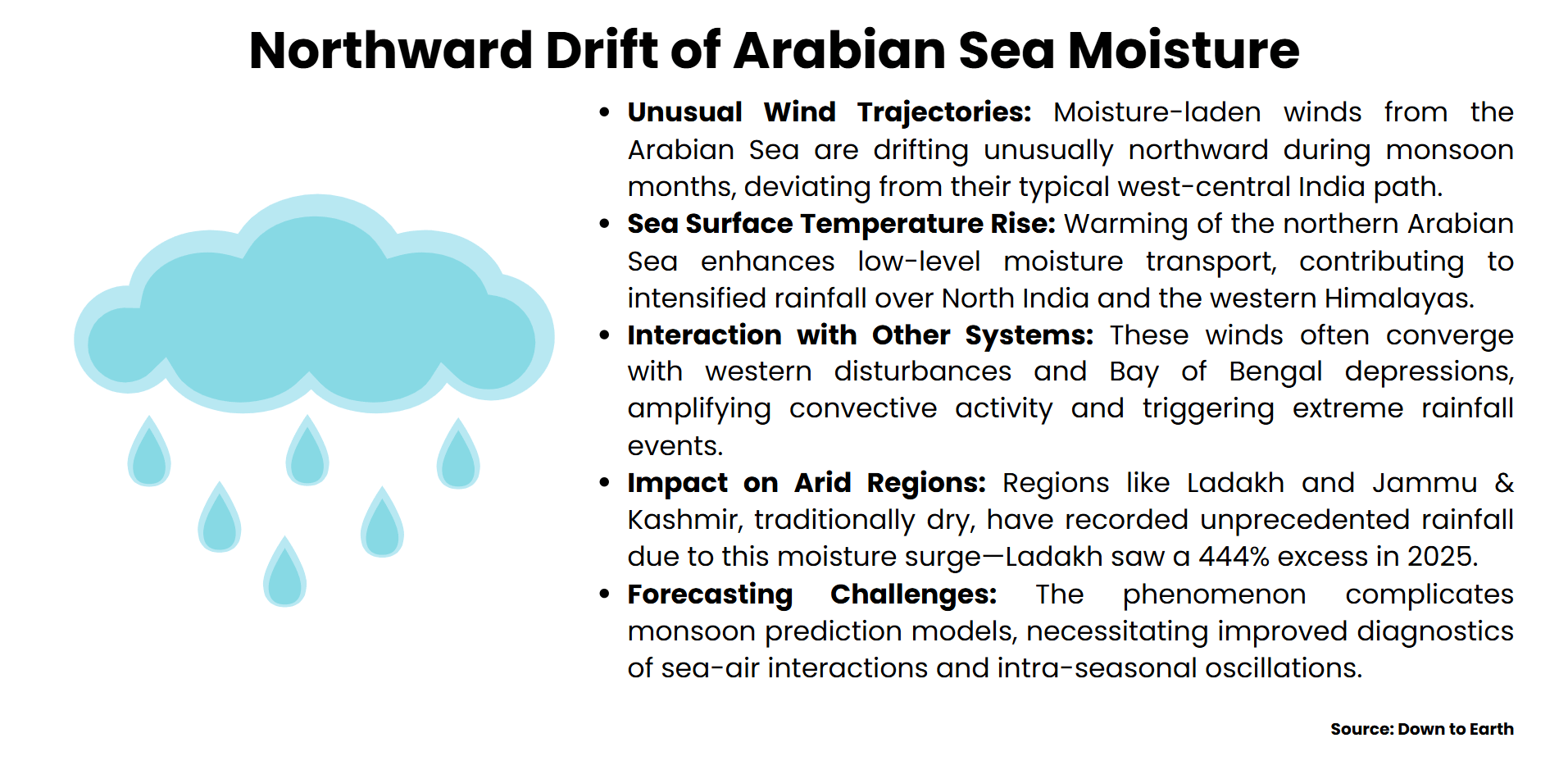
Recently, the monsoon season in North India has been characterized by a strange northward movement of the moisture laden winds of the Arabian Sea. This has had a strong impact on the distribution and strength of rainfall in the whole region.
Arabian Moisture
Low-level jet streams and cross equatorial flows usually control the humidity to be carried by the wet winds, namely the southwest monsoon, with the feeding of the Arabian Sea. However, recent observations have shown pole-ward movement of such systems of winds as a result of the changing temperatures of the sea surface and the dynamical instability of the northern Arabian Sea. This change boosts the convergence of moisture along northwestern India, leading to the intensity of rain that breaks the climatological levels. These changed patterns of wind movement are also due to the Silk Road Pattern, i.e.,an anomaly in mid latitude followed by circulation changes that alter the pressure gradients and encourage northward advection of moisture.
Monsoon Depressions and Western Disturbances
The action of the northward invasion of the Arabian moisture is not isolated. It is often interacting with monsoon depressions that are formed in the Bay of Bengal and the Mediterranean, western disturbances. These interactions form multi layered cyclonic circulations, which increase the intensification of convective instability and causes severe and extreme rainfall events. Such convergence has caused record-breaking precipitation in Ladakh and Delhi in 2025 to emphasize the compound character of these systems. The active monsoon phase is also extended by the inflow of moisture, and it slows down the process of withdrawal, making the area highly vulnerable to floods.
Climatological Drivers and ENSO Effect
Large-scale climate processes likeEl Nino-Southern Oscillation (ENSO) cause further modulation of the northward drift. In the presence of post-La Nina conditions, the meridional gradient of sea surface temperatures is increased over the equatorial western Indian Ocean, and the cross-equatorial flows are reinforced, as well as resulting intra-seasonal oscillation propagates northwards. Another important factor is the background available convective cellular instability over the Arabian Sea, whereby increased moist static energy leads to sustained invitation to transport moisture.
Forecasting and Regional Planning
This changing moisture feedback requires the factoring of monsoon forecasting models. The conventional theory is no longer adequate. Better methods of diagnostics of the sea surface anomalies, using jet streams, and teleconnection patterns are crucial for correctly predicting anomalies. The policy players should incorporate these findings in flood management, city planning, and agricultural advisory services to curb the impact of increased strong rainfall regimes.
|
Basics
La Niña and El Niño
|
|
El Niño-Southern Oscillation (ENSO) is an equatorial Pacific phenomenon coupled to the ocean-atmosphere system that has a far-reaching effect on the global climate systems, including the Indian monsoon. ENSO has two opposite phases, El Niño and La Niña, which have particular sea surface temperature deviations and atmospheric pressure variations.
The warm stage is referred to as El Niño, where there is abnormal warming of the eastern Pacific Ocean, and the trade winds are weakened. This interferes with the Walker circulation and stifles convection in the Indian subcontinent, which is likely to result in a deficiency of monsoon rainfall and drought-like conditions. On the other hand, the cool stage or La Nina implies the presence of more trade winds and cold Pacific water that intensify monsoon winds and normally lead to an increase in higher-than-normal rainfall in India.
The stages also contribute to the occurrence and movement of tropical cyclones, western disturbances, and oscillations intra-seasonally. Knowledge of ENSO creates importance in South Asia through seasonal predictions, agricultural development, and related disaster preparedness.
|
Policy Implications and Compounding effects
The North India convergence of the abnormal weather systems, which include the western disturbances during monsoon and northward moisture surges along the Arabian Sea, has given rise to compound rainfall extremes that ought to increase the demands of disaster that have overstretched governance structures.
The Element of Synergy
Simultaneously, the weather occurrences increase in intensity when several meteorological drivers interact and lead to outcomes that are even worse than what the individual systems could ever create. Western disturbances and monsoonal troughs have, at the same time, experienced heavy winds due to the amount of moisture in North India, resulting in rainfall amounts never before recorded. These engagements increase convective instability, increase active monsoon stages, and cause flash floods, landslides, and urban flooding. The case of the 2025 monsoon season was no exception, as there was a case of 52% and 444% percent surplus rainfall in Delhi and Ladakh, respectively. Such a non-linear amplification requires a change back to non-linear hazard models rather than compound risk frameworks.
Infrastructure and Emergency Stress
The intensified physical infrastructure and emergency response systems are under great strain due to the compound effects of rainfall incidents. The loosely designed urban drainage networks are overloaded, with infiltration loads corresponding to historical and present-day rainfall levels. Acute or sequential extreme events shrink recovery periods within the communities, rendering those in crisis slow to regain the capacity of their fighting abilities. In mountainous countries, the highly moist soils as a result of heavy rainfall enhance landslides, and the river system has cascading flood risks. The presence of these cumulative hazards undermines the ability of a disaster response and increases economic damage, as identified by recent investigations in compound hazard mapping.
Policy Voids and Predictive Uncertainty
Existing disaster risk reduction (DRR) efforts tend to consider hazards independently without the consideration of the cause-and-effect relationships among concurrent systems. Although the forecasting models have been improving in terms of their resolution, they have yet to model the multi system interactions with the needed lead time. The absence of unified early warning systems and territory-specific vulnerability analysis makes the matter of challenge even more complicated. A systemic knowledge of interdependent risk and adaptive policy frameworks to manage compound disasters effectively is noted as a need by the United Nations Office for Disaster Risk Reduction.
Towards Climate Resilience Governance
The governments need to spend on dynamism in forecasting, multi-spread maps, and resilient structures development. Hydrological stress testing needs to be introduced into urban planning and agricultural advice to adapt to the new rainfall regimes. Adaptive capacity can be improved by means of community-based disaster preparedness backed up by decentralised data systems and participatory decision-making. The future heart of cognitive resilience is in the inclusion of compound risk analysis within the national climate plans and disaster management plans.
Conclusion
The growing overlap of normal and deviant weather systems, especially the jerky influx of western disturbances during the monsoon, and the northward shift of Arabian Sea atmosphere has radically transformed the rainfall patterns in north India. These interactions of compounds have increased the occurrence and intensity of hydro-meteorological disasters, defying traditional models of forecasts and infrastructural durability. The lateral and temporal randomness of the rainfall events implies that the area undergoes a paradigm shift in a way that climate risks cannot be treated within the single hazard context, but concentrates on a multi-system approach to study. With the escalation in variations in climate, it can be argued that governance on adaptations of regions should focus on vulnerability mapping, areas-specifics, dynamic early warning systems, and planning of resilient cities and agricultural phases. There is a need in the future to be able to decode the changing behavior of atmospheric circulations and how they interact with compounds to produce systematic monsoon variation. An interdisciplinary solution to address the recurring effects of rainfall disasters and protect livelihoods in all of North India with its varied ecological and socio-economic contexts, a strong interdisciplinary response package, or a combination of meteorology, hydrology, and policy science, is required.