|
Key Highlights
- Delhi a semi-enclosed basin
- Prevalence of temperature inversion
- Increasing Pollution Levels
- Urban Heat Island (UHI) effect
- Formation of microclimates
|
This article focuses on the role of the topography of the city of Delhi, which is distinctive in that it includes basin-averaging terrain, slow airflow, and temperature constraints of the dispersal of pollutants, and worsens winter air quality.Delhi's "topographical disadvantage" means its location and surrounding geography turn the region into a natural "bowl" or "valley" that effectively traps air pollutants, especially during the winter months.
|
Tips for Aspirants
To provide a detailed analysis, topicality, geographical context, and insight into the terrains that are essential in mains and interview, this article includes geography, environmental science, and policy as major areas in the UPSC and State PSC syllabi.
|
|
Relevant Suggestions for UPSC and State PCS Exam
- The topography of Delhi is a semi-enclosed basin that is surrounded by the Himalayas and the Aravalli Hills, which entraps the pollutants and prevents dispersion.
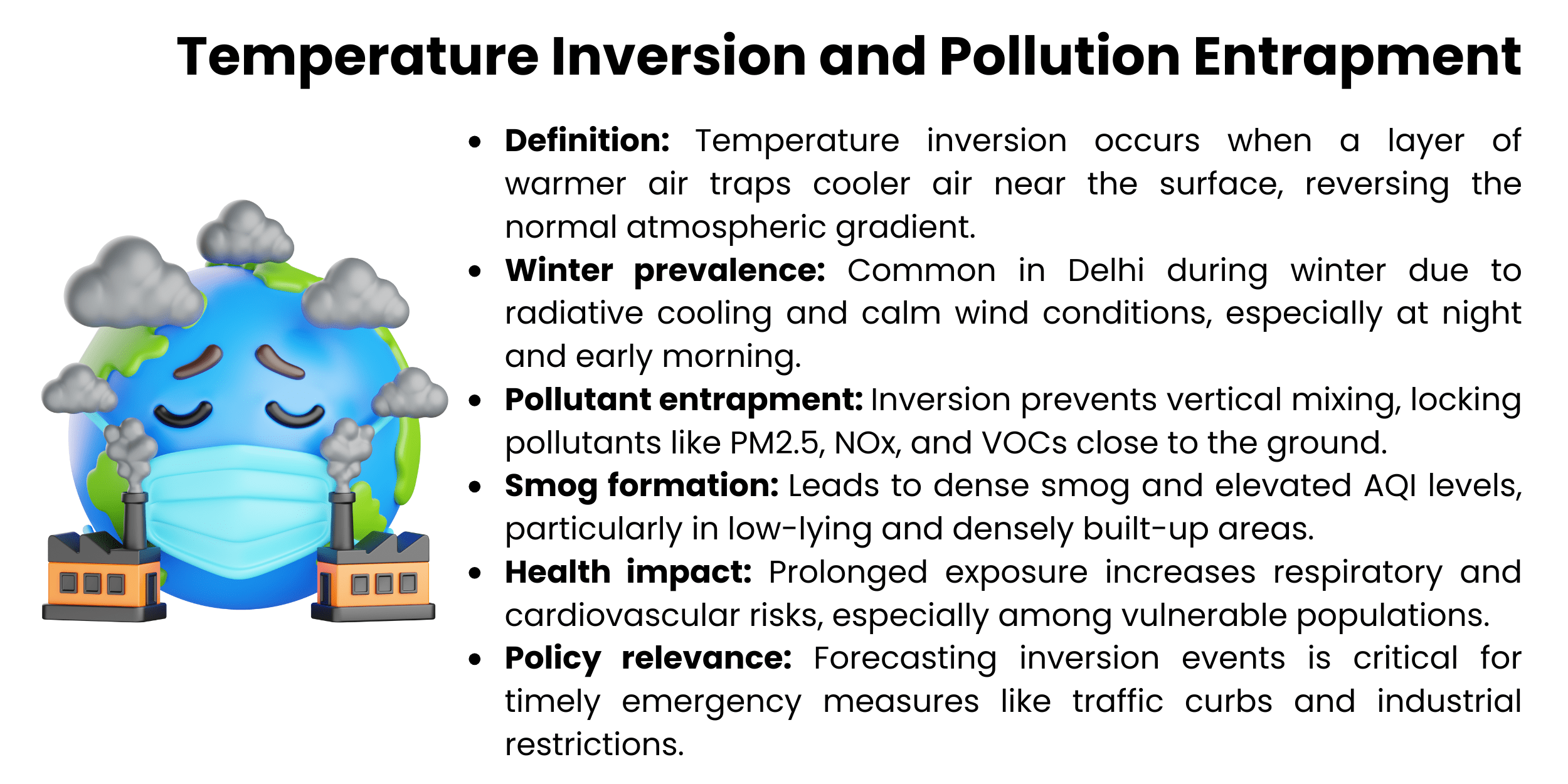
- In winter, temperature inversion will hinder vertical mixing, and hence pollutants will be trapped in the near-surface layer and increase the choking of smog.
- In regions of low altitudes and during calm winds, radiative cooling and cold-air pooling take place, which causes much of the entrainment of pollutants.
- The Urban Heat Island (UHI) effect enhances thermal gradient formation, strengthens inversion layers, and slows down the dissipation of pollutants.
- The built environment, where high-rise buildings and small streets are densely built, inhibits natural ventilation and leads to a micro-climate with a high level of pollution.
- The exposure risks in the poorly ventilated regions are increased by the spatial clustering of emissions.
|
Air pollution in Delhi has become a continuous environmental and public health crisis, with the greatest activity during the winter months when the synoptic meteorological conditions and manmade emissions interact synergistically to produce dangerous atmospheric situations. Although it is generally accepted that vehicular emissions, industrial discharges, the combustion of biomass, and construction-related dust can be regarded as the key contributors to air pollution, there is a lack of literature discussing the role of local topography and spatial processes in general in mainstream academic literature. Delhi is also located in the Indo-Gangetic Plain and is surrounded by the Aravalli Range on three sides, and this creates a semi-closed basin that significantly influences the way pollutants are transported and trapped. This geomorphology increases the building of temperature inversion layers during periods of low wind speed and falling temperatures, such that the pollutants in the air are trapped in the near-surface layer and hence restrict vertical mixing. In addition, the urban morphology of the city is tight, consisting of densely constructed territories and scattered green landscapes, which enhances the effect of the urban heat island and limits natural ventilation. An interaction between these spatial and topographical constraints and the meteorological conditions enhances the severity of air-quality episodes, as well as the duration of these episodes.
Understanding How Delhi’s Geography Traps Air Pollution
The Article critically examines the enhancement of the air-quality problem in the local topography and spatial structure of Delhi, especially under the circumstances of seasonal shifts and transitions. Through the combination of the foresight of environmental science, urban planning, and atmospheric dynamics, the discussion outlines the urgency of the policy of terrain sensitivity in the road to reducing the long-lasting air pollution issue in the city.
Geographical Basin Effect
The geographical basin effect of Delhi is a serious factor aggravating the air pollution during the winter when the weather is stagnant and the pollution accumulates. This part examines the space dynamics of this phenomenon.
The Semi-Enclosed Terrain of Delhi
Delhi is located on the Indo Gangetic plain with the Himalayas lying to the north and the Aravalli hills to the southwest. This topography becomes semi-enclosed,which forms a basin-like topography that limits the horizontal and vertical spreading of air pollutants. In winter, the topography is a self-determined trap, and over time, particulate matter (PM2.5 and PM10), nitrogen oxides, and other pollutants are deposited on the ground. Through its geography, unlike the city of the coastal areas, where wind can play a role in freshening the air caused by sea breezes, and where the area is fairly open, Delhi is prone to extended periods of pollution.
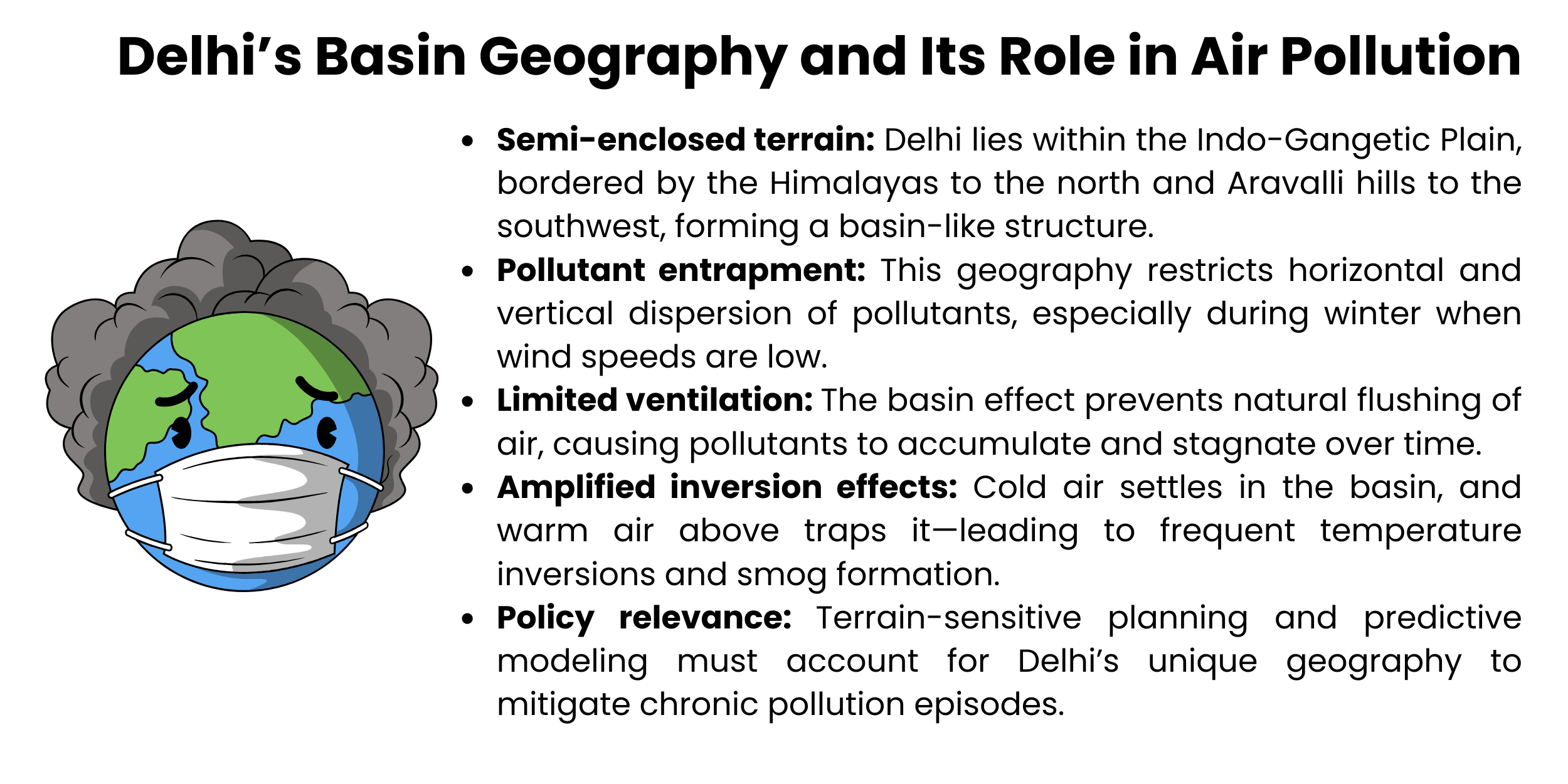
Atmospheric Inversion and Encapsulation of Pollutants
This effect of the basin is enhanced by the frequent temperature inversion that takes place in winter. During the decrease in surface temperatures, the colder air is confined near the surface, whilst the warmer air is closer to the surface, and thus, no vertical mixing can take place, and therefore, pollutants within the lower atmosphere are not mixed up. The effect is increased in the basin-like environment in Delhi, resulting in visible smog and unhealthy pollution levels of AQI. Absence of vertical ventilation states that the emissions of the vehicles, industries, and biomass burning are suspended near the breathing centres.
Stagnation of Wind and Disruption of Airflow
Topography in the city of Delhi is a contribution to local wind patterns. The hills and true urban morphology that can be seen around its environment disturb the natural flow of air, especially during the post-monsoon months when the wind speed is usually low. This stagnation halts the horizontal movement of contaminants, wherein they are prone to settle and accumulate in the lowlands. Research has indicated that variations in the direction of wind, or the speed, can cause a significant shift in the extent of pollution, an avalanche factor revealing how terrain can modify the quality of air.
Implications on terrain-sensitive planning and policy
The geographical basin effect needs to be known to produce the necessary mitigation strategies. The spatial disadvantages can be mitigated through terrain-sensitive urban planning, improvements of green corridors, mitigating emission hotspots where there is low-lying land, and taking advantage of artificial ventilation methods. Further, real-time surveillance and predictive models should include the topographical parameters in order to enhance the early warning measures and emergency rescue guidelines.
Stagnation and Patterns of Wind
Wind circulation during winter in the city of Delhi is a critical determinant of air quality in the city. This part will look into the ways in which stagnation and airflow obstructions further cause collateral pollution trapping.
Weaknesses of Wind Seasonality and Their Implications
Delhi also undergoes an acute decrease in the velocity of wind in the post-monsoon and winter seasons, usually between October and January. This atmospheric stillness in the season largely suggests that there is no proper scattering of pollutants. In winter, unlike summer, where winds are stronger to ventilate the city, the motionless winter wind causes the build-up of particulate matter and gaseous pollutants closer to the surface. The deficiency of kinetic energy in the air suggests that vehicle, industrial, and biomass burning emissions stay for longer periods without ultimately resulting in smog checks as well as escalated Air Quality Index (AQI) scores.
Disruption of the Airflow caused by Terrain
The topography of the city also makes wind dynamics difficult. The Aravalli hills envelop Delhi, and the city is within the Indo-Gangetic Plain, which forms a semi-closed basin that interferes with the flow of natural air. These are the geographical formations that serve as obstructions and modify the direction of the wind and decrease its speed. Consequently, the pollutants are likely to accumulate in regions with low altitudes and urban centres with high populations of construction workers. Supplies of the built environment, such as high-rise buildings and small streets, also play a role in micro-level stagnation by blocking the wind paths and reducing cross-ventilation.
Exposure to Temperature Inversions
The stagnation of the wind frequently comes hand in hand with the events of temperature inversion, whereby there is a layer of hot air, containing warm air trapped by a layer of cooler air and pollutants close to the surface. Without adequate wind, such layers of the inversion last longer, thus making the level of pollution worse. Weak winds together with the inversion layers lead to stable conditions in the atmosphere that are resistant to vertical mixing, which practically traps pollutants within the breathing zone. This has especially become hard in early mornings and late nights, where temperature gradients are the strongest.
Urban Planning and Forecasting
Knowledge of wind stagnation is critical to coming up with responsive policies concerning urban and environmental design. Forecasting of the air quality should incorporate the data on wind speed and direction to accurately predict the pollution events in real-time. The design of cities must give priority to open spaces and green corridors, and ventilation channels to enable the flow of air. Besides, the emergency response strategies, including traffic control and industrial security, should be dynamically connected to the forecasts of the wind stagnation to eliminate the potential of exposure.
Cold Air Pools and Temperature Inversion
Cold air pooling and temperature inversions make up critical meteorology operations that enhance air pollution in Delhi during winter. This part analyses their processes and spatial connotations as perceived in the context of urban topography.
Urban Basin Mechanism of Temperature Inversion
Temperature inversion is marked by the occurrence of a stratum of warmer air, overcooled air closer to the ground, and therefore turning the traditional gradient of temperature. This effect is extremely accentuated in the basin-shaped topography of Delhi at night during the winter months and at dawn in the morning. This inability of the solar heating and radiative cooling of the land surface leads to the ensnaring of the cold air in low-lying areas. The warmer air that lies on top acts as a lid and suppresses the mixing of air vertically, and keeps the pollutants, such as PM2.5, nitrogen oxides, and volatile organic compounds, trapped in the proximity of the ground. As a result, some noticeable accumulation of smog is achieved, along with a significant increase in the respiratory health risk.
The development and Maintenance of Cold Air Pools
The formation of cold air pools in discrete situations. It occurs when gruff, cold air accumulates in a topographical depression, which is particularly influenced by still wind conditions. The semi-enclosed nature of the country and the complex structure of the city in Delhi encourage the creation of such pools in the outer areas and neighbourhoods with high populations. Such pools cannot easily dissipate because of low wind flows and minimal solar radiation in winter. This causes the suspended pollutants of the vehicular traffic, industrial effluents, and biomass burning in the atmosphere to linger in these stagnant air masses. These cold air pools continue to be caused by consecutive days may cause cumulative pollution burdens that raise the Air Quality Index (AQI) to the ranks of very poor or severe.
Topographical Enhancement of Inversion
The topography of the city of Delhi and inversion interactions enhance the effects of pollution. The location of the city is on the Indo-Gangetic Plain, surrounded by the Aravalli hills, limiting the horizontal airflow and enhancing the steadiness of the inversion layers. Developed city landscapes also block ventilation in nature, which strengthens the trapping of cold air and contaminants. Such a spatial arrangement creates microclimates where the effects of inversion are amplified, especially among the residential and industrial suburbs, which are situated at a low level.
Relevance of policy and strategies of adaptation
There is a need to understand the importance of both the temperature inversion and cold air pools in developing adaptive air-quality management approaches. The topographical and meteorological data should be incorporated in forecasting models where inversion events are predicted with high accuracy. The transit of cold-air pooling through urban planning efforts should focus on developing ventilation corridors and using green infrastructure to discontinue cold-air pooling. Action measures, including traffic bans and Industry closings, should dynamically be associated with the inversion predictions to avoid exposure risks.
City Heat Island and Built Environment
There is a strong effect of the built environment and the dynamics of the urban heat islands on the retention of air pollutants in Delhi. The role of spatial construction and thermal gradient in the growth of winter smog and stagnant atmosphere is discussed in this section.
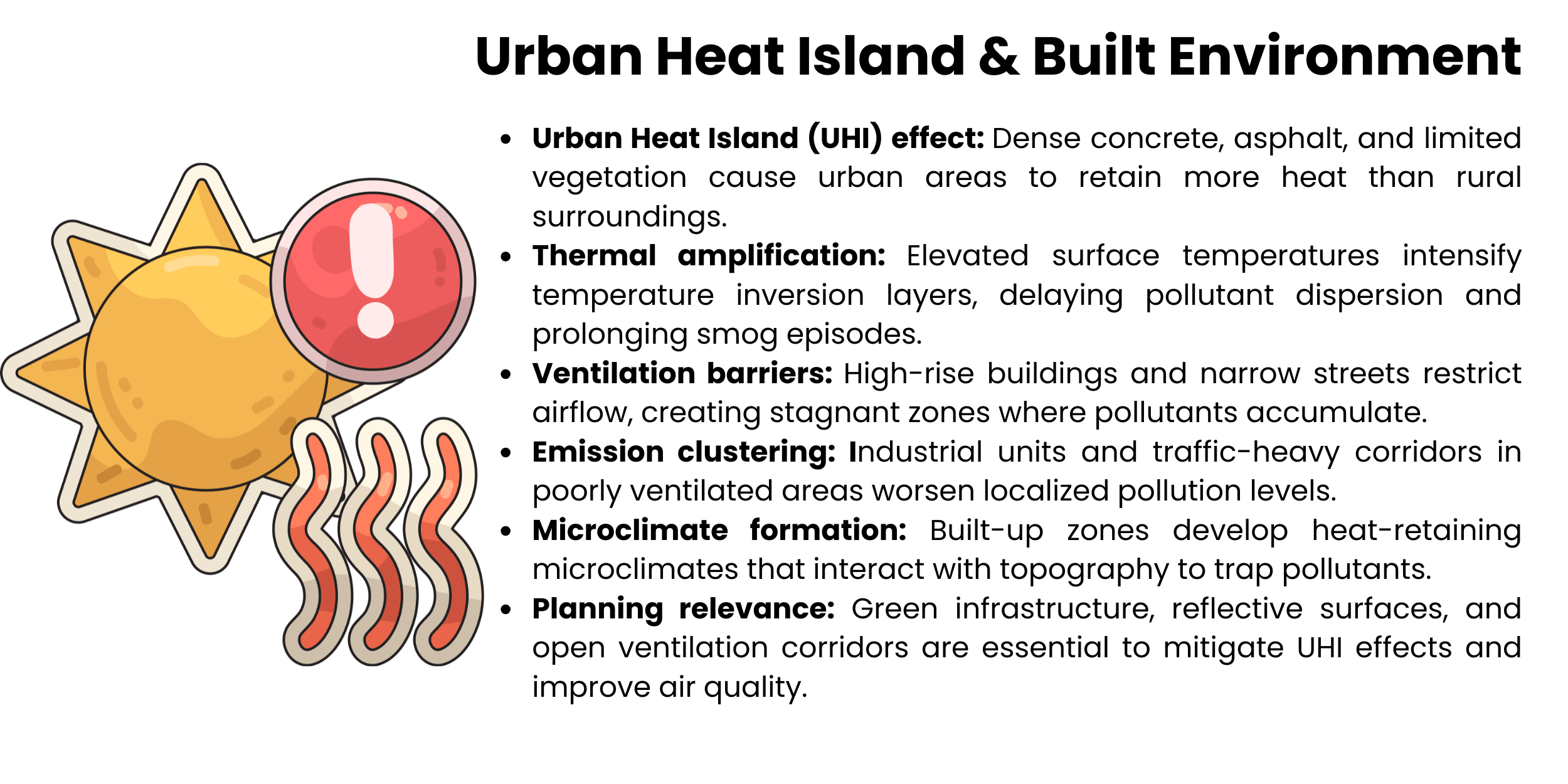
Heat Island Effect and Thermal Inequalities
The urban heating island phenomenon is the phenomenon that cities are observed to be at high temperatures as compared to the national settings with a high density of infrastructure, and this phenomenon is a result of anthropogenic activities. In Delhi, widespread concrete and asphalt surfaces combined with poor vegetation increase the temperatures of the surface, especially when it is daytime. These thermal differentials also interfere with normal cooling cycles and increase nocturnal temperature inversion, which creates traps of pollutants near the surface. Moreover, the UHI effect changes the local wind provisions and reduces the dispersion ability of pollutants, which excludes greater air motion stability.
Ventilation Constraints and Built Environment
The form of the built environment in Delhi is that of high-rise buildings, narrow lanes, and thick construction, which hinders the natural ventilation of the environment. The lack of open spaces and the mis-designed urban structures inhibit the horizontal movement of air and form systems of micro-environment, favoring the development of pollutants. These spatial constraints turn out to be very severe in low-income and industry districts, where building densities are as great and green cover as small as possible. The concentration of the sources of emissions in such poorly-ventilated areas also increases the risks of exposure and leads to the local pollution hot spots.
Dynamism with Topography and Meteorology
There is a synergistic relationship between the built environment, the topography, and the meteorological conditions of the city of Delhi. In winter, when wind speed is slow and temperature inversions are usually prevalent, cold-air pools are retarded due to heat trapped by surface areas in cities. This delay increases pollutant-trapping and increases smog. In addition, the spatial nature of the buildings may either direct or block the existing winds, hence the dispersion of pollutants within the neighbourhoods. The discussed relationships confirm the importance of considering urban morphology in the airdome modelling and mitigation techniques.
Adaptive Design and Planning Interventions
The UHI effect and issues with ventilation require terrain-sensitive city planning. The use of strategies that will reduce heat load, e.g., increasing the vegetative cover, installing reflective roofing materials, and building ventilation corridors, can improve air circulation. Green infrastructure development as part of urban renewal programs and the implementation of zoning policies to eliminate the clustering of emissions are a must in achieving long-term air quality benefits. Furthermore, it is necessary that the predictive models have built-environment variables so as to improve the precision of the forecasts of pollution and emergency response planning.
Conclusion
To sum up, the air-pollution crisis in Delhi is an unresolved issue unless there is the inclusion of the spatial and topographical variables that define the dynamics of the atmosphere. A combination of a weak seasonally blowing and non-directional nature of the seaside, compounded with the low temperatures, coupled with the pooling of cold air, creates a natural trap of pollutants in the city. In addition, the city's urban heat island and high density of populations also exacerbate stagnation and inhibit natural ventilation, especially in the winter season. These contributors have a synergistic relationship, and consequently, they enhance the extent and duration of episodes of pollution. As a result, the need to focus on the air-quality issues of Delhi entails using a multidimensional approach, which incorporates terrain-sensitive city-planning, meteorological prognostication, and emission-related strategies. The policy frameworks should go beyond the source-based interventions, including the spatial diagnostics and the adaptive infrastructure design. The implementation of sustainable and fair air-quality enhancement opportunities in the city is only possible through recognition and addressing the key issue of the city being based on the unique geographical conditions, which explains the immediate necessity of interdisciplinary cooperation of environmental scientists, urban planners, and policymakers.