A trend of stubble burning in Punjab is interpreted in this article, and examines recent indications of fire incidence actually decreasing, the possibility of numerous burnt hectares going undetected, and misrepresentation of environmental data and policies in reaction to the shortcomings of satellite observation systems. "From Fields to Fog Rethinking Punjab’s Stubble Burning Metrics" refers to the growing recognition that current methods for measuring stubble burning incidents in Punjab—primarily satellite "fire counts"—are inadequate for capturing the full scope of the problem.
|
Tips for Aspirants
This article is useful for the aspirants of UPSC and State PSC as it clarifies the interrelatedness of environmental governance, satellite technology, and policy analysis as the central themes in the General Studies papers, the essay writing, current affairs, and ethics paper.
|
|
Relevant Suggestions for UPSC and State PCS Exam
- Fire counts/ burned area: A decline in fire counts as per satellite-detected data in the Punjab, but it does not always translate into an equal decline in overall stubble burnt.
- Data anomaly: There can also be fewer, but larger fires in use that are covered by more acquired acreage; this avoids detection due to the satellite limitations.
- Satellite constraints: The cloud cover, low spatial resolution, and procedures to overfly locations hinder proper fire detection.
- Algorithmic thresholds. Sensors on satellites can either miss low-intensity fires or temporarily burn fires and there could be a misdetection of non-agricultural heat sources.
- Temporal evasion: The farmers can also burn their stubble when there is no satellite overpass planned and avoid being detected.
- Policy risks: Overreliance on fire counts can lead to a risk of not only relaxations in policies but also the creation of misdirected policies where air-quality responsiveness strategies are created.
- Public health outcomes: Underreported fires may distort the prediction of pollution, thus affecting the health warning and emergency planning.
- Required ground-truthing: Field surveys, unmanned aerial vehicle pictures, and interviews with the farmers are essential to verifying satellite data.
- Governance lesson: total monitoring is essential to the development of evidence-based environmental policy and the enhancement of popular accountability.
|
Stubble burning, being a constant event in Punjab, is a real issue of environmental and health concern, especially in the post-harvest months of October and November. The latest official records show a drop in fire incidents, which have often been interpreted to take into account an improvement in compliance and the effectiveness with which the policy has been implemented. However, this seemingly diminishing observer leads to skeptical consideration of the devotion of the metrics of fire counts, and it could happen that a destabilization in the log of events could occur alongside an associated increase in the area covered by fire. It was found that even the use of technologically advanced satellite-based fire-detection networks is afflicted by systematic limitations, such as interference with cloud cover, poor spatial resolution, and poor (intermittent) temporal coverage, which might trigger an underlying systemic underreporting. In addition, the algorithm used in thermal anomaly detection can have a poor ability to differentiate between crop residue ignition and other sources of anthropogenic or natural heat, thus further reducing assessment accuracy. This article, therefore, critically considers the question of whether the reduction in the Punjab stubble burning issue is an authentic process or an artificiality of the required method owing to limitations, scrutinizes the difference between stated counts of fires and estimated acreage of fire, the effectiveness of satellite surveillance, and the necessity of further supportive ground-level checks.
The article aims to educate more subtle policy-based responses with the help of the data analysis and its explanation, which will contribute to the creation of evidence-driven, transparent environmental governance.
Paradox of declining Fire Statistics
Although on paper it is being claimed that things are improving, empirical evidence, which relates to stubble burning in Punjab, reveals a paradoxical situation: the number of fires may fall, and it does not always mean that it will lead to a real reduction in environmental destruction. This is a contradiction that is analyzed in this section.
Apparent reduction in fire incidents
According to the latest reports of the Punjab agriculture monitoring agencies, there has been a marked decrease in the occurrence of stubble-burning incidents. By 2024, the number of fires that were recorded had decreased by more than 70 percent compared to the previous years. This decline has often been interpreted as an increase in farmer compliance and good policy measures, such as subsidized machines and sensitization. However, such a reading can be examined more closely, especially in light of widespread haze and waning air quality that were witnessed throughout northern India during the same period of time.
Inequality between Fire Counts and Area Burnt
Even when the annual incidence of fire has decreased, the satellite-obtained measures of the total area of farmland that is burned show performed well with virtually no or slight changes. This contradiction suggests that they could be having fewer but greater combustion incidents, where farmers burn larger farms in single incidents rather than in multiple smaller incidents. This practice may even go undetected by detection limits set up by satellite algorithms that tend to only encode unique thermal anomalies. This means that the visible decrease in fire cases will hide the actual extent of biomass burning and its environmental consequences.
Shortcomings in Satellite Detection
The occurrence of the technological limitations involved in monitoring satellites continues to compound the paradox. The presence of cloud cover, low spatial resolution, and low frequency of revisit cycle can be sources of underestimation of fire events. Furthermore, there is anecdotal evidence that some farmers intentionally burn stubble at night to beat the satellite passes to avoid detection due to temporal voids in the satellite passes. These weaknesses suggest a lack of confidence in the quality of fire-count data as a stand-alone indicator of the trends of stubble-burning.
Population Implications
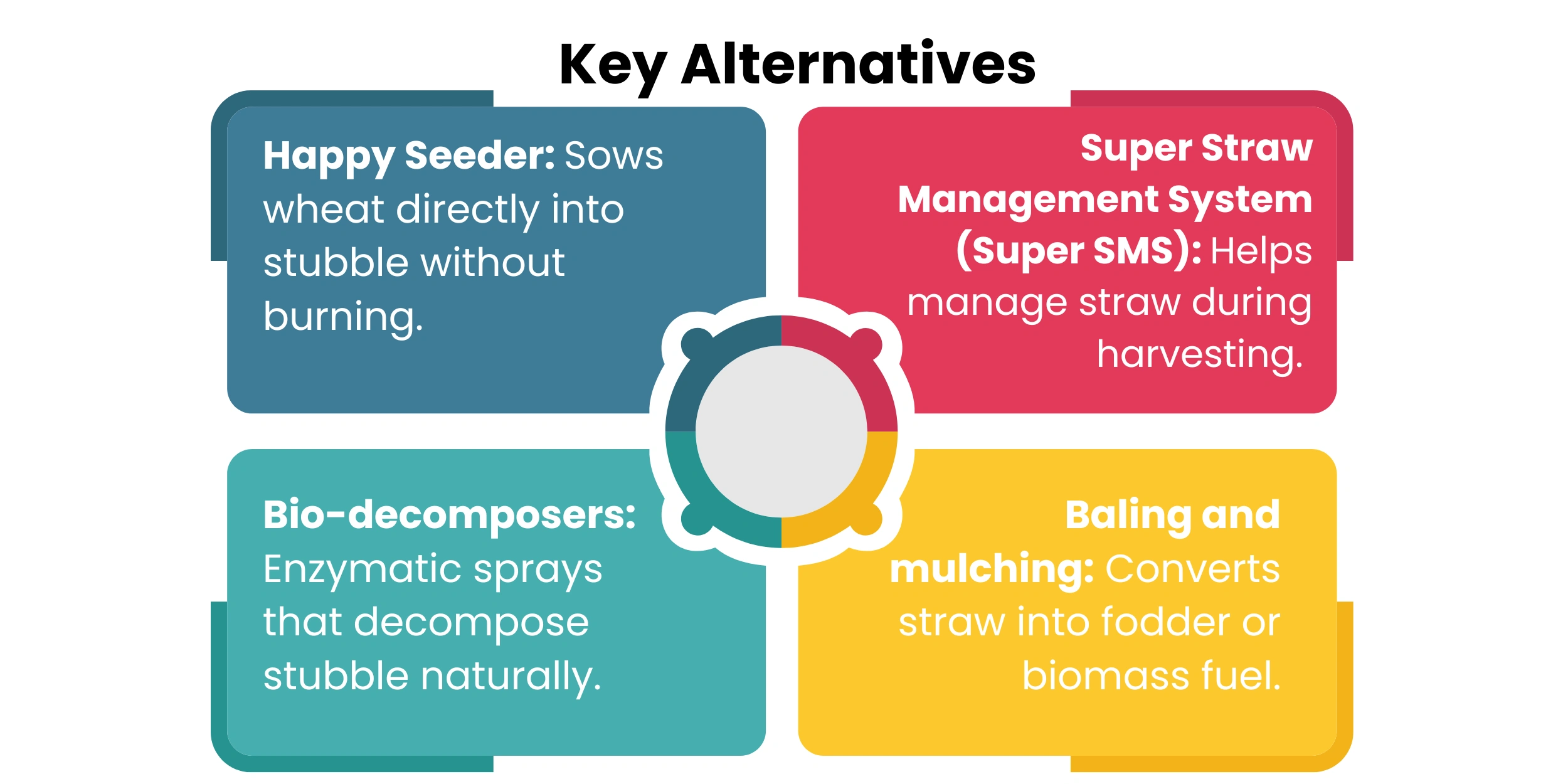
Relying on the fire to be an indicator of environmental amelioration can reduce this complex issue to simplicity. Policymakers can announce victory too soon and not pay attention to the fact that ecology is deteriorating. Moreover, the official statistics can give the wrong impression of the population, so it is possible that they do not understand the seriousness of air pollution and its health consequences. A more sophisticated methodology, a combination of satellite data and ground-based surveys and interviews with farmers, etc., is something that can be done for more accurate evaluation and effective intervention.
|
Why is stubble burning a major cause of air pollution in northern India?
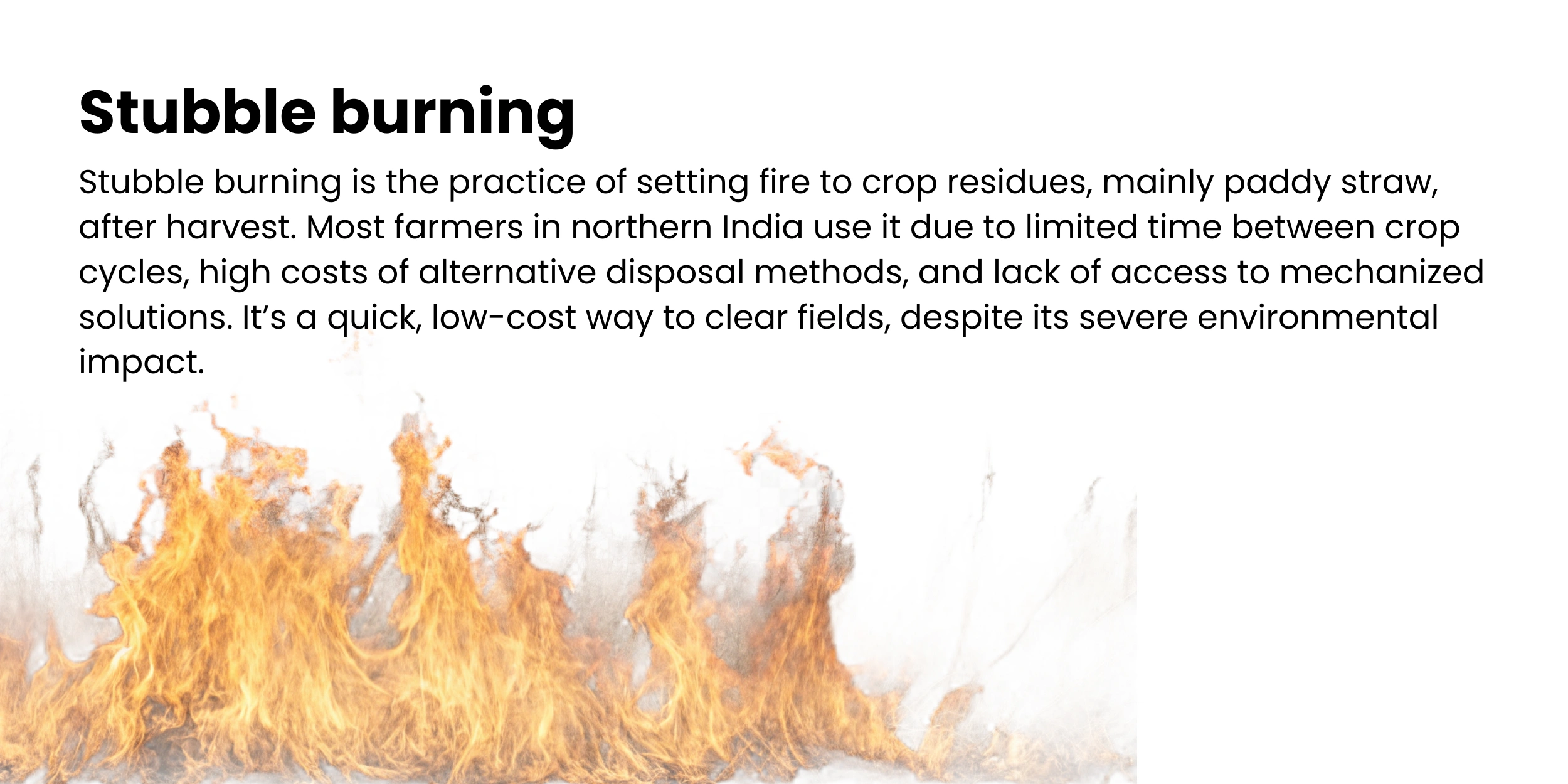
Stubble burning is the major source of seasonal ambient pollution in the North Indian states, especially in the months of October and November. The method entails burning up crop remnants after harvesting, with the majority being paddy stubble. The activity is practiced in Punjab, Haryana, and the west of Uttar Pradesh because there is a short temporal window between the end of paddy harvest and the start of wheat planting, which is further aggravated by the prohibitive price and lack of available alternative methods to manage the residues.
During stubble burning, high volumes of carbon monoxide and nitrogen oxides are emitted into the air in addition to the particulate matter (PM 2.5 and PM 10) and volatile organic compounds. These gases worsen the air quality in the environment and lead to the creation of ground-level ozone and secondary aerosols. The dominant meteorological regimes, which are the low speed of winds and temperature inversion in northern India, highly contain the pollutants in the lower troposphere, thus increasing the formation of smog.
The worst air quality is observed in this season in Delhi and nearby areas, where stubble burning contributes to up to forty percent of peak-day PM 2.5 concentrations. The pollution is transboundary and makes it difficult to contain, as well as requiring state-wide action regarding the problem.
|
Fire Counts vs. Burnt Area: What the Figures Hide.
Even though the officialised fire counts seem to allegedly demonstrate a decreasing pattern of cases of stubble-burning in Punjab, it would appear that a more in-depth investigation will reveal that the reduced costs might be an indicator of a greater agricultural biomass burning.
Fire counts as a Proxy Indicator
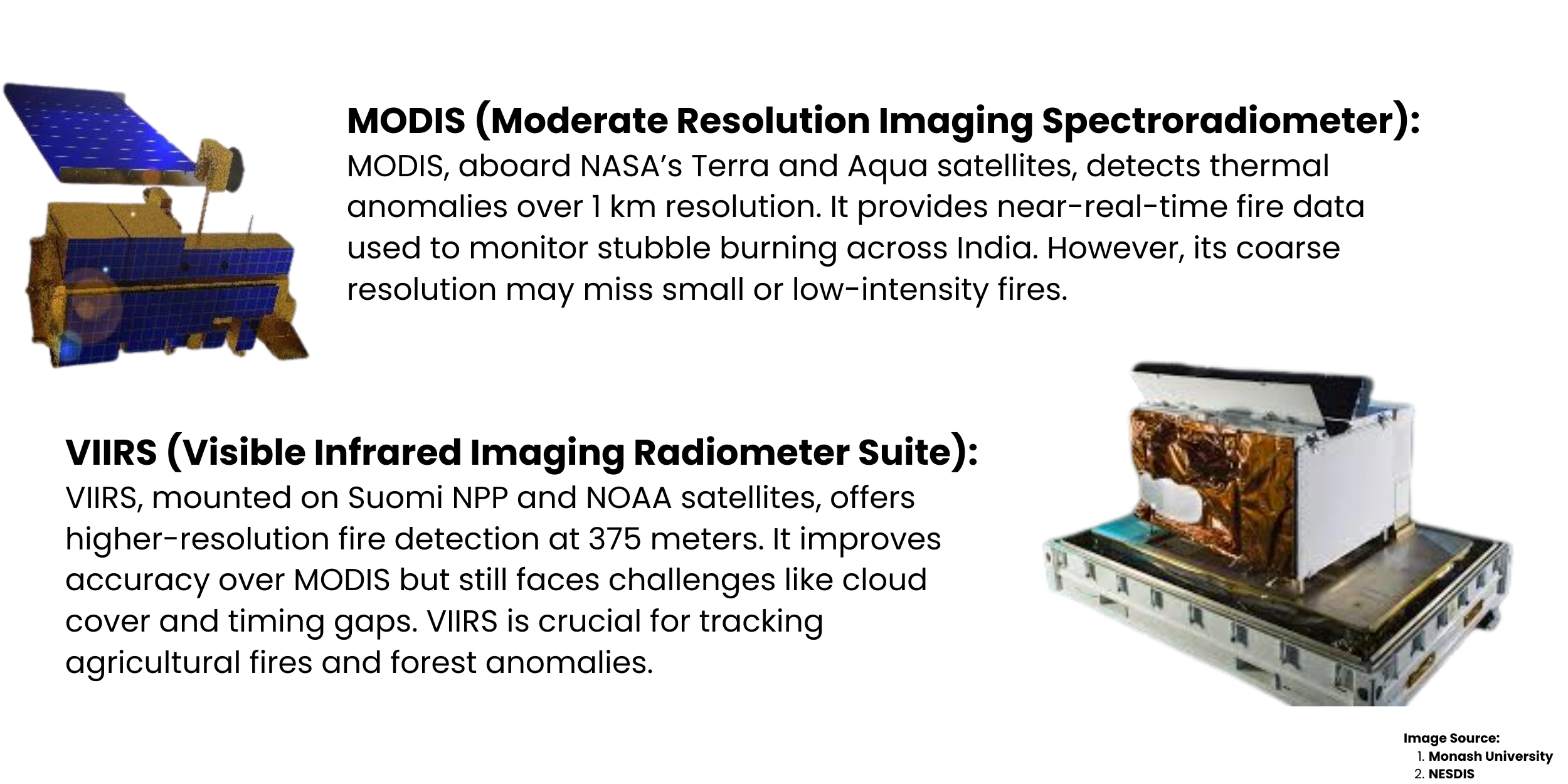
The thermal anomaly detection systems of satellites (MODIS and VIIRS) are often used to determine fire counts, which are used to estimate the prevalence of occurrences of stubble-burning. Such numbers are frequently taken as direct indicators of the improvement of the environment. This technique, however, assumes a one-to-one relationship between fire incidents and area burnt, and as a result, reduces the intricate world of agricultural burning activities. To avoid detection or, rather, less work, farmers can combine residue in fewer, larger fires, thereby reducing the frequency of fire events with no commensurate decrease in the area burnt.
New Signs of Burned Area
Recent examination by the Indian Agricultural Research Institute (IARI) and other researchers on the environment suggests that the number of fires has decreased, but there is no corresponding reduction in the overall area of burning. There are bigger, continuous greens of burned fields in specific districts using satellite images, which may suggest that less number of fires may be contributing to the burning of more biomass. This tendency discredits the use of the metrics on the fire counts in terms of stand-alone measurement and suggests the shift to the more comprehensive burnt-area assessments.
Detection Thresholds and Time Lapses
Satellite sensors work within a given range of detection limits that may fail to notice low-level or short-term fires. In addition, satellite over passes are done at regular periods and often fail to detect fires that may have been caused when there is not a peak demand, like in the early morning or the evening hours. These limitations give farmers an opportunity to plan their burning events to beat the odds. Further, the thermal signatures may be obscured by the cloud cover and atmospheric haze, leading to underreporting. These technical limitations create blind spots in fire surveillance systems, where there is a lot of burning that goes undetected.
Policy Risk
The use of fire counts as an evaluation, poses high risks of misinformed decision-making. When interventions are deemed successful, just because the number of fires decreases, authorities can erroneously cut funding, enforcement, which will result in undermining the trust of society and serving as an obstacle in long-term mitigation efforts. A stronger monitoring system - combining satellite imagery with on-ground surveys, drone photography, and interviews with farmers is needed to obtain the dimensions of stubble burning, as well as to respond to an effective policy.
Lapses in Data and Satellite Limitations
Although a sophisticated model of fire detection systems through satellites is technically advanced, the fire detection systems face several important limitations that hinder the effective evaluation of stubble burning in Punjab.
Temporal and Spatial Resolution constraints
Satellite detector systems like the MODIS and VIIRS have set orbital patterns and, therefore, take pictures of an area once or twice every day. This has the disadvantage of a limited capability in time because fires set by lightning sources that could be under the satellite overpasses when such overpasses are not in place, such as the first thing in the morning or near the end of the day, in many cases, go undetected. Further, the spatial resolution of these sensors, which is usually between 375m to 1 km, can be incapable of detecting small or weak fires, particularly those spread between fragmented farmlands. This reduces the integrity of fire count information as an effective instrument of management.
Atmospheric interferences and cloud cover
Cloud, haze, and smoke plumes seriously impair the ability of satellites to ascertain thermal aberrations. Northern India often has dense land-based, obscuring atmospheric conditions in the optimal season of stubble burning. It is therefore likely that satellite sensors will not pick up the active fires or will underestimate the intensity. Existing evidence has shown that pixels that are obscured by clouds can cause significant underreporting to occur and especially in humid areas or post-monsoon transitions.
Algorithmic Threshold and Misclassification
The algorithms that are used to process satellite data are based on predetermined thresholds used to detect fire events. Such thresholds are adjusted to notice high amplitude heat forms, but would miss smaller fires or transient fires. One can also add thermal anomalies that arise because of non-agricultural causes, e.g., brick kilns, industry emissions, or controlled burn, to a falsely labelled as stubble burning. This brings out false positives and false negatives, hence misrepresenting the general illustration of biomass burning. Unless contextual validation is carried out, the outputs of such algorithms will be confusing to policymakers and researchers.
Absence of ground-level reports
Although satellite information can be useful at a macro-level, it cannot provide the localized information needed for analysis at a localized level. Satellite observations should be checked by ground-truthing with field surveys, drone image analysis, and interviews with the farmers to remove detection errors. However, validation attempts at this are intermittent and insufficiently financed. The absence of integral monitoring schemes restricts the ability to triangulate the sources of information and form a trustworthy image of the stubble-burning processes.
Implications on Policies
There are significant policy implications of reliance on fire counts determined by satellite to analyze the trend of stubble-burning in Punjab. This section discusses the dangers of possible misinterpretation of data and explains the need to validate the data at a ground level.
Deceptive Measures and Policy Blind Spots
Satellite fire counts commonly serve as key markers of achievement in stemming the stubble burning as practiced by government agencies. The existence of these figures commonly results in less enforcement or budget reductions, and fewer mitigation efforts. Nevertheless, as mentioned above, fire counts are not necessarily a good measure of the overall area burned and the level of biomass burning. Such a falsehood causes a policy blind spot where progress that seems to be happening can actually cause environmental deterioration. Using imperfect information can hence cause untimely optimism and complacency in governance.
Community Health and Air Quality
A critical public health crisis that is still ongoing is air pollution in northern India, especially during the after-harvest season. Air-quality predictions and emergency preparedness may fail to be satisfactory in case policy action is based on fire cases that are underreported. The lack of correlation between fire-count information and actual contaminations invalidates the effectiveness of communication on health matters to people and breaks the citizens' confidence. An accurate data is not just important regarding the control of the environment but also the protection of struggling people against respiratory and other health hazards caused by pollution.
The Case of Ground Truthing and Combined Monitoring
In order to overcome these issues, ground truthing should be a key element in stubble-burning evaluation. Field surveys, drone surveys, and in-person interviews with farmers and reports of the local administration can deliver context-based information that supplements the satellite data. Combining remote sensing with ground-based validation in the form of integrated monitoring frameworks allows the more accurate mapping of burnt lands and a superior interpretation of the behaviour of farmers. These methods can also be used to differentiate the intentional burning action and unintended fires, which is why more specific measures can be taken.
Way to Transparent and Adaptive Policy Design
Radioactive data culture and flexibility in policy are required towards long-term solutions. The policymakers need to be aware of the weaknesses of the satellite information and invest in a multi-source validation system. This involves working with governmental institutions of learning, civil society groups, and the local government authorities. Through being more holistic and participative, governments can come up with policies that are responsive to ground realities and robust enough to stand the uncertainties of data.
Conclusion
To sum it up, the noted reduction in the fire-related cases of stubble-burning observed in Punjab based on the number of fires as detected by satellites will require a thorough re-evaluation. Despite the fact that such metrics offer a practical proxy to monitor, they have serious limitations, such as temporal discontinuities, high spatial resolution, atmospheric interference, and algorithm thresholds that reduce their accuracy. The discrepancy between small numbers of fires and the continuation or even growth of the area of burning underlines the inefficiency of using the data from remote sensing alone in the policy-making process. This contradiction threatens the distortion of governance policies and weakens the health action measures of people in an attempt to mitigate air pollution. To deal with these issues, the challenge would demand a multi-pronged system of monitoring that incorporates both satellite monitoring with ground-based measurements, including field research, unmanned aerial vehicle imagery, and engagement of the farmers. It is only under these rigorous and transparent methodologies that policy makers are able to establish adaptation, evidence-based responses that are harmonious with the environmental realities as well as the lived experiences of agricultural communities.