The Kamchatka receives a magnitude unlike any other, but given its location on the Ring of Fire in the unstable subduction zones.
A massive earthquake with a magnitude of 8.8 on the moment magnitude scale rattled off the coast of Russia near its Kamchatka Peninsula and gave way to numerous tsunami reports and aftershock across the seismically active zones ranging on both sides i.e. East and West. Although the high magnitude of an event is likely to attract the attention of the world and, in general, such an event is hardly expected, its location, in this specific area, is not such an unusual situation. Kamchatka is in the middle of the Pacific Ring. The peninsula already has the deep subduction zones, regular volcanic action, and a history of engulfing mega-thrust quakes, making it an old potential victim of large-scale seismic disturbances.This article decodes reasons as to why Kamchatka quake, despite being statistically unusual, fits well into the geological rationality of its environment. We analyze its tectonic mechanics, its tsunami potential and its precedents along with its impact on a larger disaster issue of preparedness in an attempt to find how one of the strongest recorded shaking freezes not as an anomaly, but as a severe reminder of nature seismic movements in one of the most fragile areas of the planet.
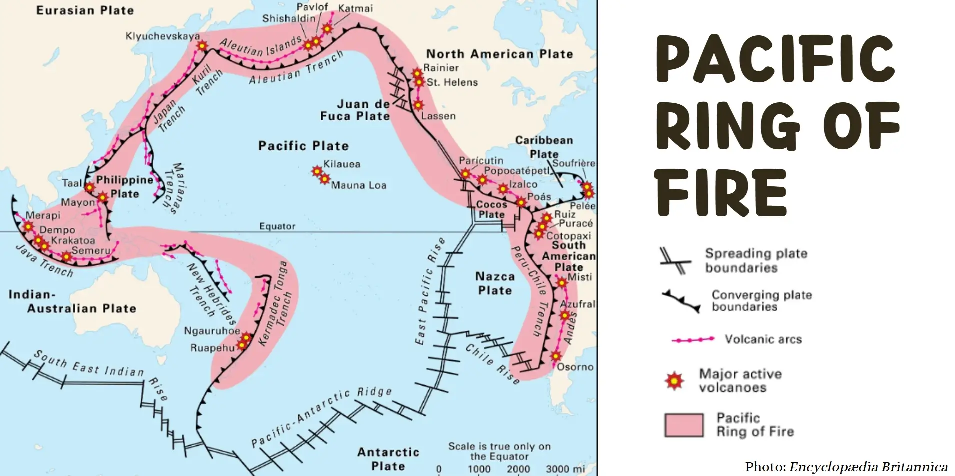
Geographical position of Kamchatka in Ring of Fire
Kamchatka is a rough terrain in the eastern part of Russia (Far East) that stretches to 1,200 kilometres between the Bering Sea and the sea of Okhotsk.
- Located along the Pacific Ring of Fire that is a tectonic belt that is marked with volcanic activity characterized by major earthquakes, Kamchatka is a dramatic land that is sparsely populated.
- Along its eastern coast is the Kuril-Kamchatka Trench where the thick Pacific Plate is being sunk under the Okhotsk microplate, a movement of classic subduction zone. The tectonic interaction contributes to the rich volcanic activity in Kamchatka, as well as high levels of earthquakes.
- One of its most potent occurrences was the 1952megathrustearthquake that was calculated at magnitude 9.0 and resulting in a destructive tsunami, one of the most powerful that was ever registered in Russia.
- Historical data refer to the previous earthquakes in 1737 and in 1841 both of more than 9.0 (magnitude), which evolves the fact that Kamchatka region is geologically inclined to high potential seismicity. Such earthquakes are not aberrations but signs of deep plate convergence and stresses built up.
Anatomy of the Quake
The megathrust earthquake on July 30, 2025 that occurred off of the Kamchatka Peninsula in Russia measured 8.8 on the Richter scale and was textbook in every aspect of a high-energy megathrust earthquake.
Epicentre and Depth
The epicentre of the quake was found around 136 kilometers east- southeast of Petropavlovsk-Kamchatsky, which is a coastal city in kamtchatka. It was formed at a shallow depth around 19-21 kilometres below the ocean surface. This was a comparatively low focal depth that enhanced ground shaking and also the possibility of tsunami formation.
Fault Mechanics
The magnitude of the earthquake was caused by reverse faulting of shallow nature in which one block or a section of the earth crust is moved, pushing up towards another. This took place situated along the Kuril-Kamchatka Trench where the Pacific plate is in the subduction process down the Okhotsk microplate at an average rate of about 77 mmper annum. A rupture zone of a length of about 390km and width of about 140km was detected and released powerful seismic energy.
Foreshock and Aftershock
The foreshock was a magnitude 7.4 a week and a half before the mainshock and was a warning sign of increased tectonic tension. After the primary event, there were more than 100 aftershocks detected, one of which was a strong 6.9-magnitude quake, within hours. Such aftershocks are a rearrangement of pressure along the fault line, and can extend up to several weeks.
Release of Energy and Duration
The cause of the disturbance lasted about 230 seconds with the seismic waves spreading across the Pacific Rim. The rupture was propagating south-westwards, and the maximum slip was more than 10 meters in certain sections. This immense movement of the seabed also played a direct role in the tsunami that was seen in Kamchatka, Japan and Hawaii.
Causes of the Quake
The earthquake centred off the Kamchatka Peninsula was high magnitude earthquake and it came as a result of deep tectonic movements at Kuril-Kamchatka Trench.
- This geological split is one of the most dynamic geological splits on earth and the convergent of the plates is at the rate of about 77 mm a year. Over decades the elastic strain is built up at the fault interface, and then, in a relatively short time, a break occurs-producing a megathrust earthquake.
- The type of fault mechanism that has led to the occurrence of this case is shallow reverse faulting whereby one block of crust is pushed over the other. The rupture zone measured approximately 390 km x 140 km and released the enormous energy of hundreds of the nuclear bombs.
- The shallow depth of the quake at around 19 kilometres increased ground vibrations and augmented the probability of occurrence of tsunami.
- Before the mainshock there was a foreshock of magnitude 7.4 that indicated increase in tectonic tension. This sequence can be attributed to the regular build-up and release process of submarine zone earthquakes.
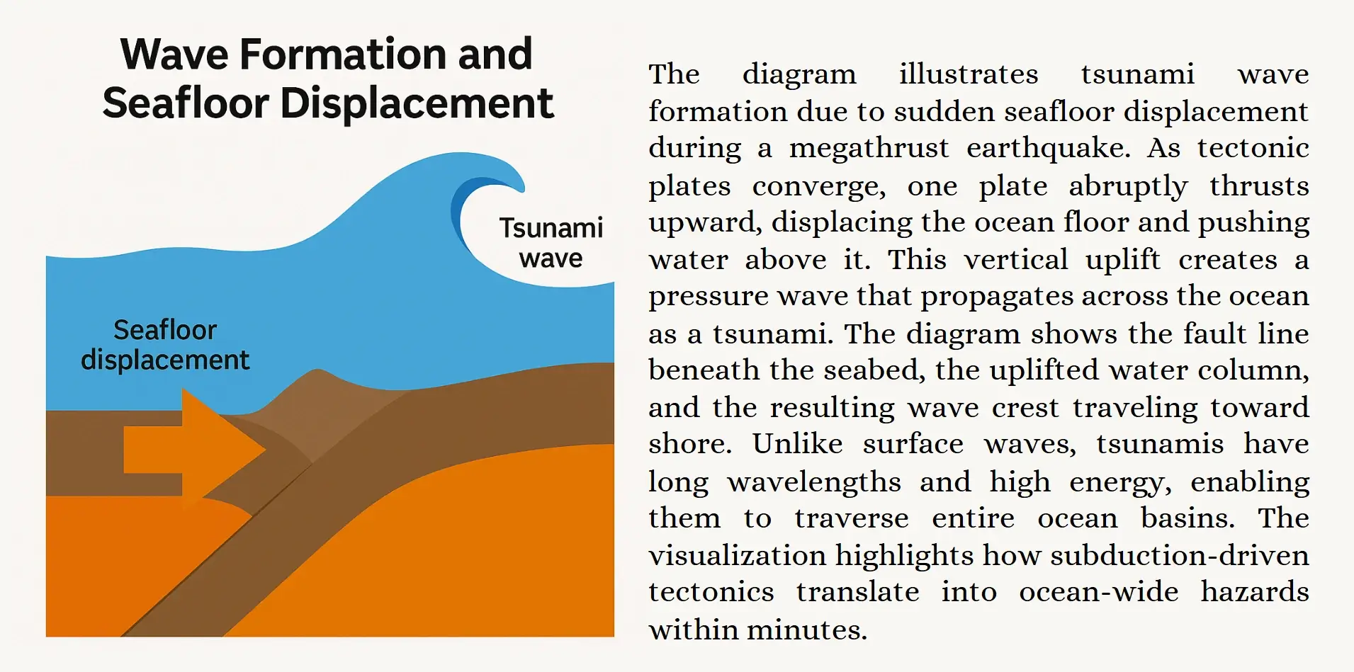
Global Alerts and Tsunami Generation
The energy released by the Kamchatka quake is so great not only that it made the entire planet rattle but it also caused the ocean floor to shift which generated tsunami waves that crossed the pacific in mere minutes putting global emergency systems on high alert.
Wave formation and seafloor Displacement
The shallow seismic focus (~19 km) and reverse fault type of deformation structure triggered sudden vertical movement of the bottom of the ocean. This sudden shift threw huge masses of water which triggered tsunamiwaves that fanned out in circular shapes. Contrary to wind-generated waves, tsunamis are mega-energy, mega-pulse waves that can travel at jet-liner velocities across whole ocean basins.
Immediate Impact
In 30 minutes, tsunamis 3-4 meters high flooded the coastal towns and towns of Severo-Kurilsk, where people had to evacuate. Russian authorities declared a state of emergency, and streets were shown to be submerged and infrastructure damaged. The Meteorological Agency of Japan issued a tsunami warning along Japan Pacific coastline with a possible 3-metre high wave to hit the Hokkaido and Tokachi regions.
Pacific-Wide Warnings and Evacuations
The Pacific Tsunami Warning Center (PTWC) issued alerts on Hawaii, Alaska, California, Chile and New Zealand. Alarms were sounded in Honolulu and the coastal regions have been evacuated on various continents. In Chile, red alerts prompted people to be relocated and Mexico and Peru closed the beaches and went into disaster protocol.
Communication and Monitoring Systems
With the use of deep-ocean buoys (DART systems) and satellite telemetry, as well as seismic networks, the propagation of waves could quickly be detected and modelled. Warnings were publicized through mobile applications, sirens, and mass media, which prove the existence of vital global interconnection in the reduction of tsunami threat.
Why it is rare but and not unusual
The Kamchatka earthquake provides ample evidence of the geological composition of the Pacific Ring of Fire, one of the most seismically active regions in the world. The Kamchatka earthquake, which has a magnitude of 8.8, is within the Pacific Ring of Fire's geological range.
Statistical Rarity
Earthquakes with magnitude more than 8.5 are regarded as very rare because only 5 such quakes have been experienced in the world in the last 20 years. The Kamchatka earthquake has become one of the strongest recorded in the history of the world and it is tied with famous ones such as Chile (2010), and Japan (2011). Its energy liberation is immense, almost 14 thousand times more than Hiroshima bombs; this is why it is extraordinary not just in keeping but in place.
Dynamics of Ring of Fire
Kamchatka also sits upon the Circum-Pacific seismic belt, in which the Pacific Plate is also descending under continental plates along several locations. This tectonic arrangement is a source of tremendous stress on fault lines, which are occasionally discharged in megathrust earthquakes. The tectonic is no stranger to such magnitude 7+ earthquakes with more than 130 having been recorded since the start of the 1900s including a destructive 9.0 in 1952.
Geological Predictability
Subduction zones can be on a long recurrence interval, decades or centuries may pass before a massive rupture. This was geologically inevitable because Kamchatka fault system had built up stress since its last major shock. Although scientists had foreseen this rupture, the question of when it was going to occur was impossible to predict.
Global Context
More than 80 percent of the biggest earthquakes on the planet are observed in the Ring of Fire. The seismic activity of Kamchatka resembles that of other subduction zones, and the conclusion that can be made is that even though such earthquakes are not as frequent, they are not considered to be surprising in tectonic hotspots.
Seismic Risk in Ring of Fire
Pacific Ring of Fire is the most geologically active area of the Earth and its length of the phenomenon exceeds 40,000 km with a shape of the horseshoe that surrounds the Pacific Ocean and causes lots of earthquakes.
- It also experiences almost 90 percent of the world earthquakes, as well as 75 percent of the currently active volcanoes, which makes it a hot spot of tectonic risks worldwide.
- The area is characterized by a complex of subduction zones, where the oceanic plates sink under the continental plates, which creates enormous stresses in the fault lines.
- Japan, Indonesia, Chile and western United States are just a few countries that are perched on the boundaries that routinely threaten them with megathrust earthquakes, volcanic eruptions and tsunamis. Specifically, the Kamchatka Peninsula is an area, which is rather active and both seismic and volcanic risks are increased due to the latest changes in tectonic plates.
- The vulnerability is increased by the urbanization in coastal faultzones in the context of the rising sea levels.
- Manila, Santiago, and Tokyo are at an added risk of shaking of the ground and infiltration by a tsunami.
- Furthermore, it is all connected so that when location is undergoing seismic activity, instabilities caused by it can exert pressure on others, routinely on view after the Kamchatka quake, with its volcanic restlessness.
The seismic tempo of the Ring of Fire is a vital step in predicting the next occurrences, enhancing early warning systems as well as the international disaster response strategies.
Conclusion
The 8.8 magnitude earthquake in Kamchatka, despite its mind-numbing size, is in balance with the tectonic pulse of one of the most geologically active regions on earth. Since the peninsula is located along the Ring of Fire, which is the result of the spectacular subduction of forces defining the Pacific rim,and its seismic susceptibility is not an anomaly. All the way back to past precedents and up to present day warnings, the quake going on in Kamchatka shows the facts that rare earthquakes are to be expected geologically as well.With the growth in the city centres towards the fault lines and the increasing rises in climate induced pressures in coastal areas, the need to ensure sound early warning mechanisms, cross-border cooperation, and people education becomes critical. The clock of nature is not very quick, but it is accurate and the alarm not to be slept by. This quake is not just a wakeup call to remind us to be prepared, but also a call to remind us that, we must get deep into the seismic story of this earth, the data to policy and science to survival.