Key highlights
- 28.6 Mha of land converted by humans
- More than half is comprised of long-lived ecosystems
- The DIST-ALERT system enabled monitoring
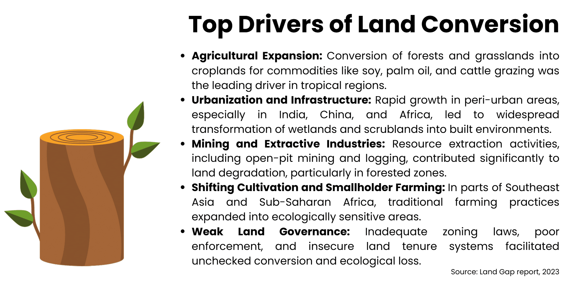
- Agriculture, urbanization, and mining etc., are major drivers
- Policy restoration and reforms are needed
|
In 2023, anthropogenic land conversion covered 28.6 mega hectares of the world's land, with an estimated half of it being found in historically important habitats. A feature of this phenomenon is the substantive degradation of world environmental integrity, systematically recorded based on a new system of monitoring land change.
Tips for Aspirants
The article sheds light on topics of environmental governance, land-use policy, and climate change as principal themes of the UPSC CSE, state PSC exams (GS Paper VI).
|
Relevant Suggestions for UPSC and State PCS Exam
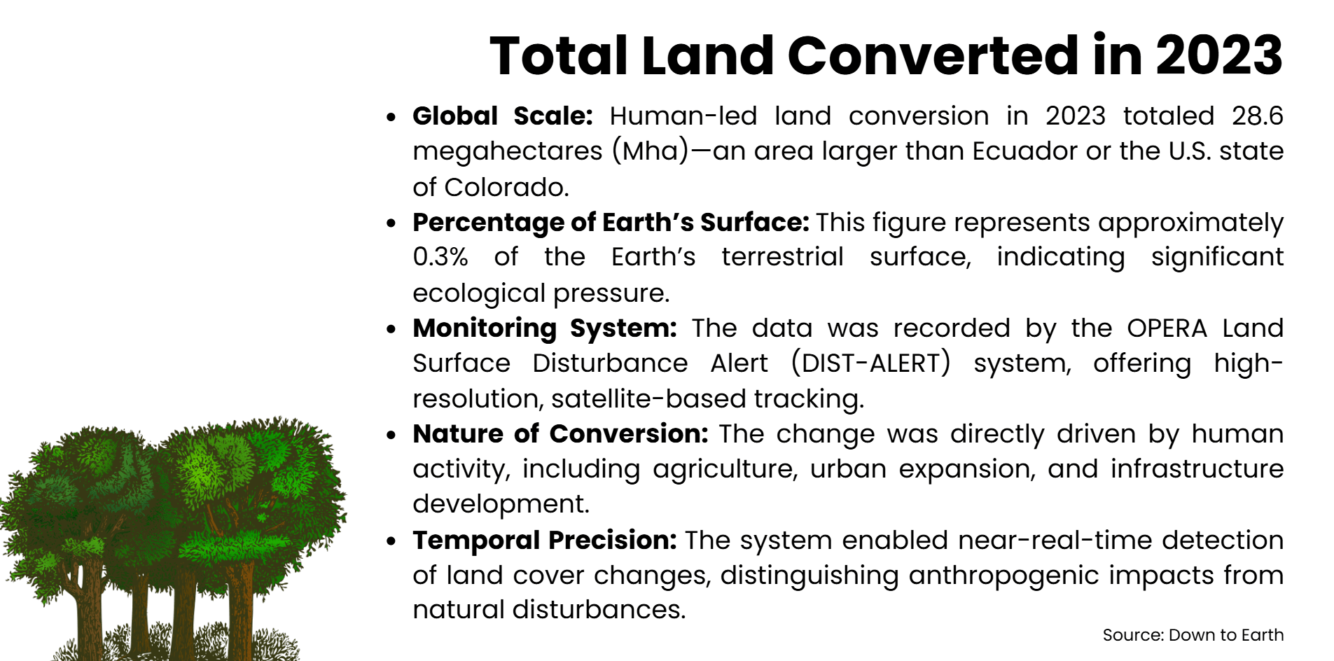
- Conversion of land: A total of 28.6 Mha of land was converted due to anthropogenic activities, higher than the area of the whole state of Ecuador in the United States.
- Breakthrough Tracking: The OPERA DIST-ALERT platform is the very first worldwide, all-inclusive, high-resolution system of land-change monitoring that takes advantage of satellite remote sensing and machine-learning algorithms.
- Ecosystem Loss: Out of the land that was converted, around half involved long-lived ecosystems, forests, wetlands, and scrublands, all important for ecological balance.
- Geographical Hotspots: The major occurrences of conversion are done in tropical areas (forested areas of the Amazon, Southeast Asia, and Sub-Saharan Africa) or peri-urban areas in India and China.
- Forces of Change: The major activities that initiated land-conversion activities are agricultural activities, urbanization, mining, and the construction of infrastructure.
- Policy Gaps: The weaknesses in land policies, the absence of enforcement, and the lack of integrated planning systems are some of the weaknesses holding back the accomplishment of suitable conservation efforts.
|
In 2023, the extent of anthropogenic change in land was a record, totalling 28.6 million hectares, an area larger than that of the land area of the state of Ecuador. This conversion, as defined by the first global land monitoring system, is a breakthrough in terms of environmental monitoring and policy argument. The intertwined half of the converted land consisted of long-lasting biomes, forests, shrublands, grasslands, and wetlands, ecosystems that are vital in the conservation of biodiversity, climate control, and ecological stability. The introduction of high-resolution sensing systems transmitted by satellites has equipped scientists with the ability to measure and provide geographically governed change of land anthropogenicity with unparalleled accuracy, providing newly acquired information on the rate and structure of land changes.
The article questions the implications of these observations on four overlapping fronts, which are as follows: (1) the technology innovation that enables the current world to be subject to land measures, (2) the spatial and numerical scale of ecosystem destruction, (3) the ecological Costs surrounding the destruction of mature and intact ecosystems, and (4) the catalysts behind such swift progress that will be carried out socio-politically. Contextualizing the 2023 data point in the paradigms of the broader nature boundaries and governance, the rhetoric aims to shed light on such fundamental policy gaps and bring a call in favour of coordinated actions at the international level.
The Global Land Change Monitoring System
Launched in 2023, the Global Land Change Monitoring System is a breakthrough in terms of providing the systematic observation of change in land use through anthropogenic changes in land use. It provides unprecedented amounts of spatial and temporal accuracy, thus improving the fidelity with which a transformation of the Earth's surface can be recorded and examined.
Genesis and Purpose
The Global Land Change Monitoring System was developed to address the soaring need for high-resolution, real-time information with regard to the transformation involving the land surface. Led by the efforts of the scientists at the University of Maryland and helped with a similar project internationally, the system, formally called the OPERA Land Surface Disturbance Alert (DIST-ALERT), was created to detect and measure manmade changes in land cover on an international scale. Its main aim will be to enhance transparency and accountability in land governance by providing working information on the speed and nature of land conversion operations.
Technological Framework and Methodology
DIST-ALERT is an interpolation of satellite-based Earth Observation data and advanced algorithmic structures to identify anomalies in land cover. It utilizes the approaches of the temporal trend analysis, change mapping, and driver attribution to distinguish the outcomes of the natural and anthropogenic modifications. Based on a variety of satellite systems, such as Landsat and Sentinel, the system uses machine-learning techniques to categorize a type of land cover and identify abnormalities. Such methodological rigor results in both the near-real-time monitoring and the retrospective analysis of results, which make it a sound tool for the enforcement and policy-making.
Findings in 2023 Dataset
In its first year of operation, the system found out that 28.6 mega hectares of land were directly transformed by human activity, and half of the land mass consisted of long-lived ecosystems, including forest lands, wetlands, scrub lands, and grasslands, just to mention a few. Such results help to understand the scope of ecological disturbance and the necessity to act. The dataset also gave an insight into regional differences and major conversions noticed in tropical areas, temperate grasslands, and peri-urban areas. Notably, the system was able to separate directly converted human changes and indirect changes that were caused by the variability of climate, fire, and other natural occurrences.
Political and environmental policy
Through its implementation of DISTR-ALERT, it has significant implications for environmental governance. It facilitates governments, civil society, and international organizations to enforce compliance with the land use rules and conservation ambitions through providing granular and verifiable data. Besides, it also aids in early warning systems against the destruction of the ecosystem and helps to implement climate adaptation measures. With an ever-rising rate of land conversion, these kinds of monitoring systems are subject to absolute necessity, to balance between the developmental aspirations and the ecological integrity.
Scale and Geography of Land Conversion
As a global signal of strong geographic inequities and significant environmental underpinnings, in 2023, anthropogenic land conversion covered 28.6 mega hectares of planet Earth.
Global extant
The total land surface utilization of human activity in the year 2023, 28.6 mega hectares (Mha), corresponds to the size of Ecuador. This amount could be roughly summarized as 0.3 percent of the land area of the Earth, which stresses the value of the anthropogenic stress on the natural terrain. Information obtained via the OPERA Land Surface Disturbance Alert (DIST-ALERT) system represents the first situation of high-resolution and globally localized direct land-use change that could be considered due to human activity.
|
DIST-ALERT
The OPERA Land Surface Disturbance Alert (DIST-ALERT) is an important development in worldwide environmental monitoring. Developed under the Observational Products for End-Users through Remote Sensing Analysis (OPERA) program, DIST-ALERT is designed to identify and measure disturbances of the land surface at spatial and temporal scales. It combines the satellite data collected by platforms like Sentinel-derived sensors - Sentinel 1 and Sentinel 2, Landsat, and uses advanced algorithms to detect any sudden land cover structure alteration due to human intervention.
Launched in 2023, it provides near real-time alerts. It uses a mixture of radar and optical data in its process of monitoring vegetation loss, urban growth, and infrastructure contraction across a wide variety of ecosystems. This is because the system provides uniform data of global dimensions, enabling policymakers, researchers, and conservationists to act swiftly to counter the emerging threats.
DIST-ALERT strengthens accountability and supports climate management advancements. It is a turning point and a transition to information-based environmental stewardship during the period of accelerated change of the ecological environment.
|
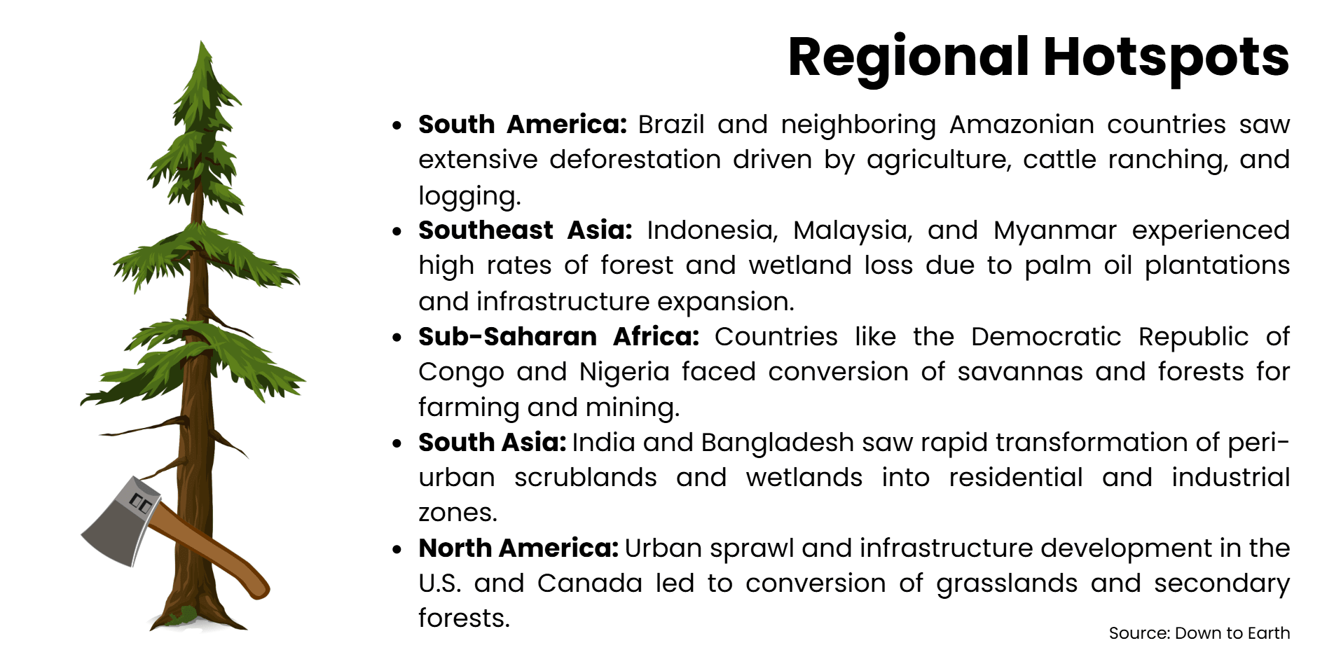
Regional Distribution
The rate of land conversion was uneven. South America, Southeast Asia, and Sub-Saharan Africa are tropical areas that were subjected to the greatest incidences of deforestation and ecosystem conversion. In Brazil and Indonesia, the process of agricultural expansion and logging became the most significant. On the other hand, in North America in the temperate regions gave rise to more urban sprawl and development of infrastructure. Interestingly, peri-urban communities in India and China had high rates of scrubland and secondary vegetation conversions to expand settlements, which is indicative of demographic impacts on development and trends in the economy.
Conservation Pattern
The total area transformed was 15.7 Mha, of which a greater part constituted long-lived natural vegetation; mature forests, wetlands, shrublands, and grasslands. Another 3.9 Mha of scrub vegetation over disturbed sites that had earlier been disturbed was also converted. The third portion of converted land was that which was produced through land uses which had existed before the application of urban development, e.g., agricultural fields and residential lawns.
Land Governance
Some of the major causes of land conversion included mining, agricultural growth, logging, shifting cultivation, and urbanization. Poor land-governance structures, lack of implementation of environmental policies, and incompatible developmental priorities often supported these activities. The results of spatial analysis that can be based on DIST-ALERT emphasize the urgent need to address regions with special measures of restoration, zoning changes, and community-based conservation projects. Without synchronized and concerted actions on global and local levels, the rate at which people are changing the land puts the climate mitigation goals as well as biodiversity promises at risk.
Ecological Impact: Disappearance of Ecosystems
Anthropogenic development covered almost 28.6 mega hectares of land in 2023, half of which made up long-lived ecosystems, which induced severe ecological impacts on biodiversity, climate stability, and landscape stability.
Extent of Ecosystem Loss
According to the OPERA Land Surface Disturbance Alert (DIST -ALERT) system, in 2023, 15.7 mega hectares of land, including mature forests, wetlands, shrublands, and grasslands, were directly converted. It means that these ecosystems are irreplaceable ecological infrastructure that in many cases is an even centuries-long ecological succession. Their removal reduces not only available habitat, but also affects ecological connectivity, hence species survival and migration pathways.
Effects on Biodiversity and Habitat Integrity
The long-lived ecosystems maintain a great abundance of endemic and threatened species. Forests and wetlands serve as biodiversity hotspots and breeding grounds to numerous species. Their conversion to anthropogenic use causes fragmentation of habitat, a decrease in populations, and increased susceptibility to invasion by other species. Also, shrublands and grasslands are important for pollination and grazers, which are central to the functioning of ecosystems. Destructions of these habitats nullify conservation efforts and speeds up the rate of extinction of the species.
Carbon Regulation and Loss of Carbon Sequestration
Forests and wetlands are also critical to the storage of carbon and the control of climate. When they are destroyed, they emit large quantities of carbon held in them to the atmosphere, contributing to global warming. Also, the wetlands regulate the water cycle of the planet, prevent floods, and purify water. Their conversion also adds to the emission of greenhouse gases, the decline of evapotranspiration, as well as the change in the patterns of the local climate. Recent studies indicate that land-use alteration continues to be among the major causes of weather anomalies and extreme climatic conditions.
|
Carbon sequestration
Carbon sequestration is the trapping of carbon dioxide (CO2) in the atmosphere and depositing it in either natural or man-made sources to counter climate change. The process is critical in the management of the carbon cycle of the Earth and the removal of greenhouse gases. Natural Carbon sinks, including forests, wetlands, grasslands, and the ocean, which absorbs carbon through biological reactions, e.g., photosynthesis and sedimentation. The most effective of these include the long-lived ecosystems like the mature forests and the peatlands because they are also capable of retaining carbon over a long period.
Human-based interventions also play a role in sequestration of carbon via afforestation, reforestation, management of soil, and the new processes of direct air capture and underground storage. Nevertheless, the destruction of natural ecosystems by converting the land, as has been witnessed in 2023, poses a great barrier to the potential of global carbon sequestration. Once forests or wetlands are cleared, the carbon stored is sent into the atmosphere, and this increases risks to the climate. In turn, this makes preservation and regeneration of carbon-strewn sceneries vital in meeting climate goals and maintaining ecological sustainability in the long run.
|
Landscape Resilience and Ecosystem Services
Besides biodiversity and climate, long-lived ecosystems are very critical for soil stability, nutrient circulation, and water retention. Their removal threatens other vegetation in the landscape, which makes the areas vulnerable to erosion, drought, and desertification. Ecosystem services loss impacts human communities, especially those depending on natural resources for their livelihood, health, food security, and as a marker of their cultural identity. In turn, the deterioration of these systems has had consequences on ecological and social stability.
Causes, Policy Gaps, and Future
Drivers of the Land Conversion
- The dominant forces that were dominant in 2023 in land conversion included agricultural cultivation, development of infrastructure, extractive industries, and urbanization.
- Small-scale agriculture and industrial agricultural activities, especially those of palm oil, soy, and beef, were significant contributors to the loss of forests and the rainforests in tropical areas.
- In the peri-urban areas, the high rate of population growth and lifestyle speculation by real estate supported the turnover of scrublands and wetlands into residential and industrial zones.
- Land degradation was even further stimulated by mining and logging activities, which are usually run under loose regulatory supervision.
- These motives are closely ingrained and imprinted in national developmental agendas and lead to a clash of economic expansion and environmental sustainability.
Poor Policy Implementation and Governance Lapses
- Even with increased awareness of land degradation, all the policy mechanisms are structured rather loosely and poorly funded/enforced.
- Most nations do not have integrated land-use policies that enable them to have a mix between conservation and development.
- Pressure brought by political and economic factors, environmental impact assessments are usually either evaded or watered down.
- In addition, insecurity of land tenure, particularly in Sub-Saharan Africa and Southeast Asia weakens the stewardship of the community and encourages exploitation.
- Climate commitments between countries, including those in Nationally Determined Contributions (NDCs), tend to be based on impractical terrestrial carbon removal ambitions that do not target the elements that may cause land degradation.
- Such a lack of connection between ambition and realisation jeopardizes the threat of worsened biodiversity, besides climate susceptibility.
Strategic Pathways Forward
The multi-pronged approach is necessary in order to reduce land conversion in the future.
- First, governments should strengthen rules over land by ensuring there is a clear zoning policy, participatory planning, and the effects of environmental investor rules.
- Second, the priorities that must be targeted by the restoration targets are supposed to be on ecologically valuable landscapes, such as old forests and wetlands.
- Third, economic interests can be aligned with conservation results with financial inducements and market systems, e.g., payment of ecosystem services and sustainable certification systems.
- Fourth, transboundary consistency can be achieved through international collaboration in order to streamline the land-use norms and keep a check on cross-border influence.
- Implementation of international surveillance software, such as in DIST-ALERT, offers a basis for accountability and responsive management.
Conclusion
The 2023 Global Land Change Monitoring System brings up the point of a possible inflection in human relations with the land ecosystem. The transformation of 28.6 mega hectares, out of which 50 percent constituted long-term forests, wetlands, shrublands, and grasslands, is evidence of the speedy rate of ecological disturbance, which could be attributed to anthropogenic influences. Such change threatens biodiversity and climatic stability and reveals vulnerabilities and development failures in system governance and fragmentation of policies. The drivers of the conversion of the land require integrated planning, fair land-tenure systems, and strong establishment structures to resolve the problem. Both development and ecological integrity must be on equal footing. The 2023 statistics should serve not just as a wakeup call, but instead become the cause of a paradigm change in the land management system and stewardship of the environment.