|
Key Highlights
- A disputed estuary between India and Pakistan
- Strategic and economic significance for both nations
- A long history from the colonial era
- Failed diplomatic efforts
- Security implications
- Recent statement by honourable Home Minister
|
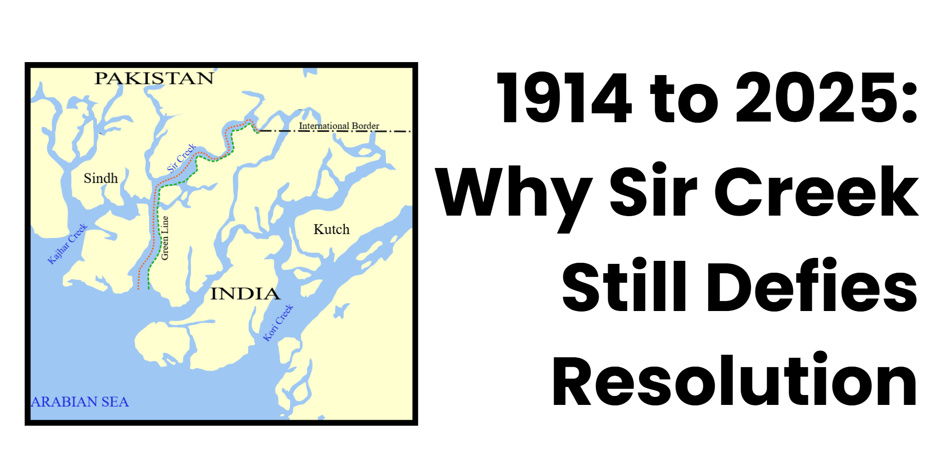
The article confronts the strategic, historical, and diplomatic aspects of the Sir Creek conflict, shedding light on why India and Pakistan have never succeeded in fixing the dispute.The Sir Creek dispute remains unresolved from 1914 to 2025 due to conflicting colonial-era maps, differing interpretations of international law, and the significant economic and strategic stakes involved for both India and Pakistan. The broader context of the hostile India-Pakistan relationship and distrust also continuously derails dialogue.
|
Tips for Aspirants
This article can be used as a tool by those that are planning to take UPSC and State PSC examinations, as this article provides connections among strategic geography, border conflict, and defence policy. The following topics are an essential part of GS Paper II, GS Paper III, the current affairs, and the essay paper.
|
Relevant Suggestions for UPSC and State PCS Exam
- Strategic importance: Sri Creek is an estuary between Gujarat and Sindh that impacts the establishment of the maritime boundary of India and the trends of the navy occupation in the Arabian Sea.
- Economic interests: The Sir Creek area has large fishing grounds and possibly a huge amount of offshore oil and gas in the area that would have an impact on the energy security and the lives of people along the coast.
- Background: The conflict is rooted in the 1914 Bombay Resolution; now India is in favour of the Thalweg principle, but Pakistan demands the eastern bank.
- Legal framework: Both states are signatories to the United Nations Convention on the Law of the Sea (UNCLOS), but differences remain in the application of the concepts of maritime boundaries.
- Diplomatic stalemate: After conducting technical surveys and multiple solutions of diplomatic deals, no mutual trust and strategic mistrust is yielding any conclusive solutions.
- Security implications: The recent warning by Sh. Rajnath Singh illustrates the shift that India is planning towards the deterrence process and the militarization of its coastal regions.
- Regional stability: The unresolved situation of Sir Creek increases the risk of miscalculation and rejection of the shared governance of maritime shipping.
- Relevance for exam: The subject is relevant to the GS Paper II (International Relations), GS Paper III (Security), and also the essay paper: India-Pakistan relations.
|
Sir Creek is a longstanding, but under-examined, maritime boundary conflict between India and Pakistan that persistently gives rise to strategic and diplomatic complexities in South Asia. The creek, in the junction of the Rann of Kutch at Gujarat and the Sindh province in Pakistan, covers a stretch of about 96kilometres and is defined by an ambiguous colonial-era ring at the turn of the century that has given rise to differing interpretations of sovereignty and related claims to the sea. The problem has yet to be solved despite numerous bilateral talks and technical survey missions, as both nations continue to have competing interests over the alignment of the creek and how the surrounding Exclusive Economic Zone (EEZ) should be respected. This strategic topography has, in recent years, become relevant due to its closeness to important naval bases, highly rated fishing fields, and probable hydrocarbon deposits. In this background, the recent statement issued by Union Defence Minister Rajnath Singh towards Pakistan in case of a mishap in Sir Creek highlights two-fold sensitivities on security and the wider geopolitical interest involved.
The article presents a critical exposition on the strategic significance of Sir Creek, the legal and historical basis of the contention, the long-standing diplomatic impasse, and concludes with what the latest move in political signalling might mean. Using a multidisciplinary approach, the article aims to shed light on the reasons why the Sir Creek problem remains a symbol of unfinished territoriality and weak bilateral trust in the India-Pakistan relationship.
The strategic and economic importance
The 96-kilometre tidal estuary of Sir Creek, located between Gujarat and Sindh in India and Pakistan, respectively, has a strategic economic significance that outweighs its map impact in the maritime/South Asian approaches to defence policies.
Geo-strategic Locations and Defence Implications
Its location near the Arabian Sea and its proximity to the commercial centre of Pakistan, Karachi, give it a critical status in the regional security architecture. Creek management regulates entry to vital maritime routes and defines the starting point of the sea boundary, which in turn determines the capabilities of naval operations and surveillance. Indian take-up, which includes front-line base and coast guard radar systems, will serve to discourage invasion as well as keep track of the military actions of the Pakistani forces. Any misfortune in Sir Creek can most likely result in a reaction, as Defence Minister Rajnath Singh recently pointed out, possibly changing both history and geography. The terrain also creates asymmetric warfare risks, such as a possible launching site to enter the country or carry out a terrorist attack, which waswitnessed during 2008’s Mumbai Attack.
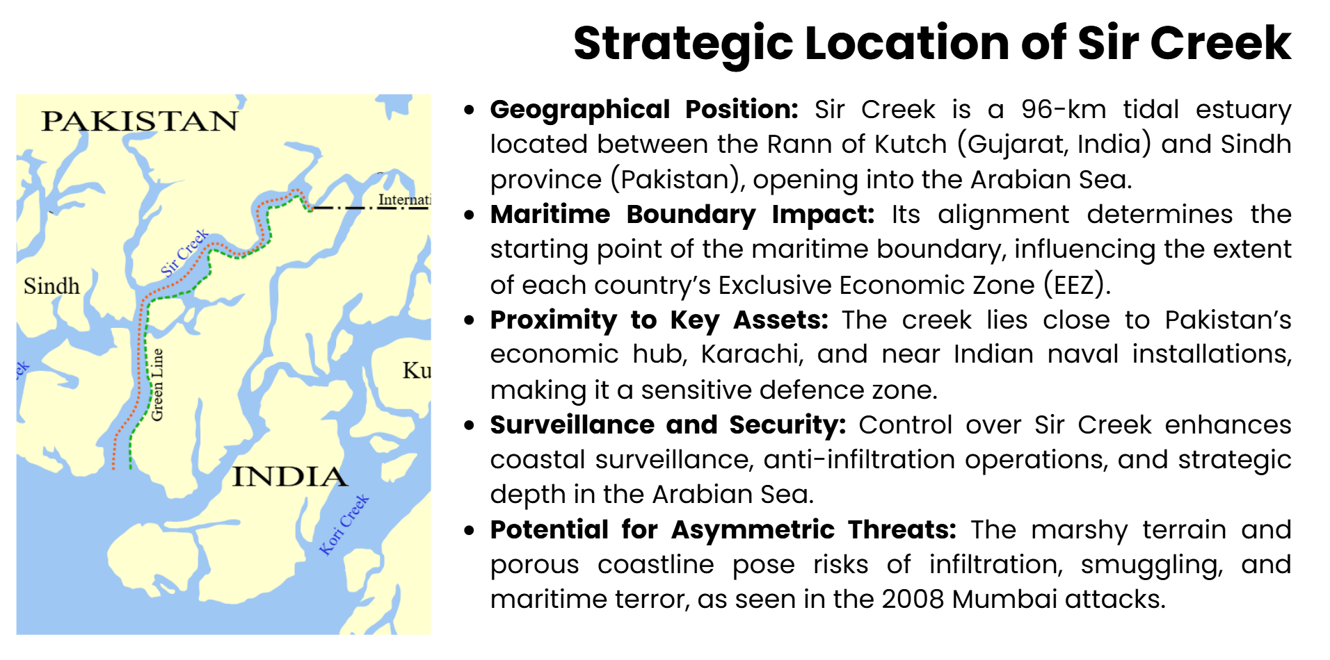
EEZs Exclusive Economic Zones
The case of Sir Creek has a direct effect on the demarcation of the maritime jurisdiction and extent of the exclusive economic zone in the Arabian Sea of each state. India asserts that it should use the Thalweg Principle, or mid-channel, as the boundary, while Pakistan claims the eastern bank, annexation, which would boost its EEZ by an estimated 250 square miles. This clash acts to complicate the jurisdiction regarding marine resources, surveillance of their privileges, and organic profundity, hence hindering the total exploitation and protection of maritime resource areas.
|
Thalweg Principle
|
|
The Thalweg Principle is an established principle in the study of international boundary law, specifically in the area of the apportionment of the riverine and estuarine boundaries. Word is of a German origin, and thalweg, in German is a kind of valley way, involving the most reasonable boundary line, which is considered the longest one, the longitudinal line running right through the deepest body of a watercourse. Relative to demarcation of boundaries, the requirement thus obligates the international frontier of two states, sharing a navigable river, to conform the thalweg, in order to ensure a fair share of access to navigation and the benefits thereof.
The Thalweg Principle takes on additional weight when enforced in recent controversial topics like the Sir Creek. The Government of India is a proponent of this approach, arguing that the international boundary must follow the deepest navigable line of the estuary and thus is consistent with current international practice and the United Nations Convention on the Law of the Sea (UNCLOS). On the other hand, Pakistan claims the eastern bank as the rightful border, citing colonial administrative records. This separation has consequential effects on maritime rights, both in regard to the Exclusive Economic Zone and the legal jurisdiction of natural resources.
Thus, the Thalweg Principle goes further and beyond being a technical guideline; it is obviously a decisive guide to the claims to sovereignty, to strategy, and the claim to international legacy in international law that gets invoked in boundary negotiations.
|
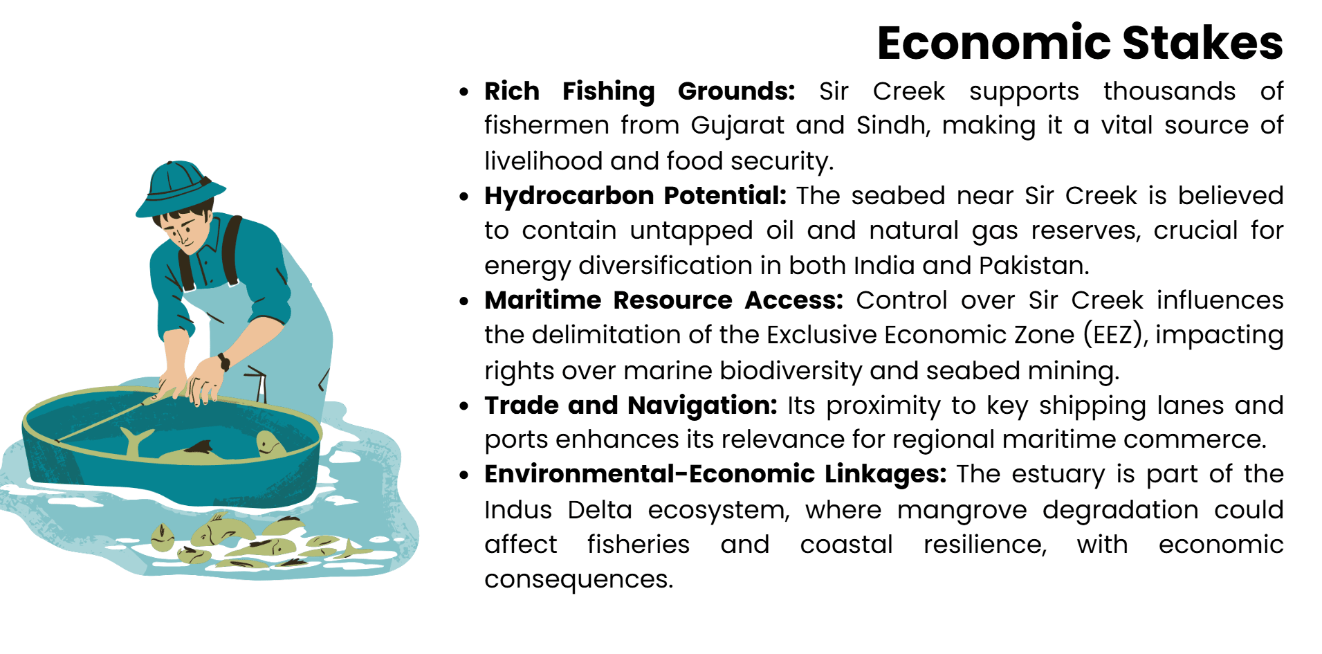
Resource Potential and Economic Stakes
On other grounds, aside from its defensive value, Sir Creek has economic significance due to productive fisheries and potential hydrocarbon basins. This estuary supports economies near the coasts of Gujarat and Sindh, and has been a disputed economic vulnerability. A survey of the seabed indicates that there could be unexploited oil and gas deposits, a resource that is all the more appealing because the two nations are working towards diversifying their power source. In the case of India, obtaining these reserves fits into its overall energy security agenda, especially in the face of soaring world oil dynamics.
Intersections of Ecology and Strategy
Sir Creek is also a part of the Indus River Delta, which is an ecologically vulnerable zone that is filled with mangrove forests and marine life. Although ecology usually withdraws into strategic thinking, ecological and economic issues, as well as security interests, overlap with each other regarding the policy and management of fishing rights and environmental degradation that would contribute to the destabilisation of local economies.
History of the Conflict
Sir Creek Dispute involving the Republic of India and Pakistan is based on a dispute over the boundary between map features that arose during the British colonial era, subject to cartographic ambiguities, complicated by post-Partition geopolitical rebranding. The source of the conflict can be dated to administrative demarcations a hundred years back.
Colonial Genesis and the 1914 Bombay Solution
The origins of the Sir Creek conflict can be traced to the 1914 Bombay Government Resolution of the administrative boundary on the border between the princely state of Kutch and the Sindh province of British India. Here, in this resolution, the line along the east bank of Sir Creek, presented vaguely enough not to be a line of actual demarcation of measures of the kingdom, but as a revenue measure. Lack of an accurate survey, as well as failure to consider boundary effects of the sea, meant that the alignment of the creek was open to further interpretation by the law. Following independence, Pakistan used this line as a foundation to represent its claim with India using the mid-channel principle, or Thalweg. The principle is consistent with existing international norms of tidal water bodies.
Partition and the Growth of Territorial Claims
After the Partition of 1947, the former Sindh province became a part of Pakistan, and Kutch of India. The shift of internal administrative boundaries into an international border brought in another twist of complexities. In India, they argued that the Thalweg rule of the boundary follows the deepest navigable channel to develop the rule as Sir Creek, and on that basis drew and placed the boundary in the middle of the stream. Pakistan, however, insisted that the eastern bank was the legitimately determined boundary, a stand which would greatly expand its maritime claim over the Arabian Sea. It is this rift that forms the basis of the long territorial dispute.
Rann of Kutch, 1965
Military skirmishes climaxed the dispute in 1965, in the Rann of Kutch area, including regions downstream of Sir Creek. The short battle, however, demonstrated the sensitivity of the region in strategic terms. A truce mediated by the United Kingdom led to the formation of a tribunal that decided on some of the land boundaries but failed to settle the Sir Creek. The partial settlement highlighted the need to adopt a special system of resolution for maritime and estuarine boundaries.
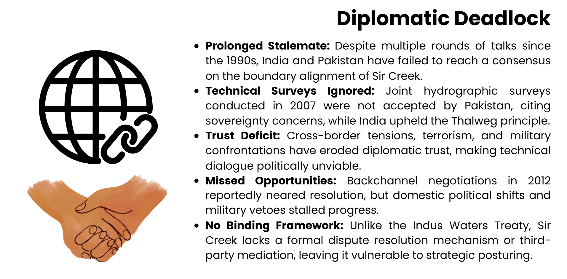
Failed Negotiations and Technical Surveys
A series of bilateral talks since the 1990s, including shared technical surveys and cartographic information exchange, had not reached any consensus. Pakistan and the demand of India to base on international maritime standards have maintained the stalemate as Pakistan is not ready to accept the joint results of the survey. Political goodwill and the larger Indo-Pakistani tensions that appear to underlie the dispute have prevented a move past the technical debate.
Negotiations and Diplomacy
The Sir Creek conflict, though a diplomatic stalemate between India and Pakistan, is an unsolvable issue decades after both countries started working together. The limitation of political and strategic aspects has, time and again, caused technical advancement to crash.
Technological Surveys and Early Engagements
Formal talks were halted on Sir Creek in the early 1990s, as part of the Composite Dialogue between India and Pakistan. The alignment of the creek through joint technical teams was based on the hydro-graphic survey in order to determine the applicability of the Thalweg principle. These questionnaires were filled in 2007 and expected to provide an unbiased ground to arrive at a solution. Yet, any further developments were halted when Pakistan refused to accept the survey results on the grounds that they interfered with its sovereignty and right to access maritime resources. India insisted that the mid-aligned standing was in line with international law, especially with the United Nations Convention on the Law of the Sea (UNCLOS) to which the two countries are signatories.
Trust Deficit and Tactical Reckonings
Failure to resolve the Sir Creek is not simply a technical problem but a highly political problem. Lack of trust between the two countries, intensified by transnational acts of terrorism, military conflicts, and nationalistic rivalry (all initiated by Pakistan), has hindered continuity in diplomacy. Pakistan views Sir Creek as a strategic buffer zone, protecting the economic core of the country, and India views it as a risk to maritime security. As such, the conflict is mired in the wider posturing of defence, in which often tactical benefit outweighs juridical clarity or economic logic.
Peer Effect and Lost Opportunities
Bouts of diplomatic thaw, including the possessions after the Agra Summit (2001) and in the extension of the Track-II efforts, offered resolution opportunities, but none led to formal deals. The backchannel talks of 2012 were reported to have come close to a settlement, but were blocked by domestic and military vetoes. Lack of continuity of the institutions in dialogue mechanisms has also stifled improvement. In stark contrast to the politically turbulent Indus Waters Treaty, the Sir Creek does not have a binding structure or a mediator.
|
Indus Waters Treaty
|
|
Among historic water-sharing agreements, the Indus Waters Treaty (1960) between India and Pakistan, negotiated under the presidency of the World Bank, is considered to be a landmark agreement that regulates the use of the Indus River basin. The treaty assigns the eastern tributaries, Ravi, Beas, and Sutlej, to India and the Western tributaries, Indus, Jhelum, and Chenab, to Pakistan, but at the same time, allows limited utilization of the western rivers by India in the form of non-consumptive purposes such as irrigation, hydropower generation and river transport.
As a product of the water-related tensions of the post-Partition era, moreover, with the presence of the key headworks on the Indian land, the IWT has survived several armed conflicts, diplomatic upheavals, to be cited regularly as a transboundary water co-operation. However, the current geopolitical tensions and civil engineering projects, most prominently the Kishanganga and Ratle Indian dams, have led to an increase in Pakistani concerns.
To civil service aspirants, the entire concept of the IWT is essential in understanding water diplomacy, conflict management, and environmental governance in South Asia, particularly in the contexts of GS Paper 2 and GS Paper 3.
|
New Rhetoric and Strategy
Maybe the change in approach has already begun with Indian Defence Minister Rajnath Singh warning Pakistan not to cause any mischief in Sir Creek. This is a strengthening of rhetoric, which means that India will declare its maritime boundaries if needed to be done. Although that kind of message helps to build national will, it also puts a stranglehold on the field of compromise. Without a new political commitment and confidence-building actions, the Sir Creek conflict runs the risk of becoming a permanent feature of unresolved border architecture configuration in South Asia.
Current Situation
Over the past few years, Sir Creek conflict has resurfaced in the India-Pakistan strategic discourse, no longer through dialogue but by aggressive use of rhetoric and counter line of defence and signalling. The shift shows greater apprehensions about regional security.
Warnings to Pakistan
Indian Defence Minister, Sh. Rajnath Singh issued a warning to the Pakistani government on 3rdOctober 2025, that any mischief in the Sir Creek area will face repercussions. Although maybe only rhetoric, his pronouncement- India today is not what it was in 1965... any wrong move will change history and geography- was more of a calculated message. The warning was made when an Indian official had been on a trip to forward positions along the Gujarat border and was underlining the fact that India was prepared to protect its coastal lines and was increasingly working on making its coastline secure. This represents a break with past diplomatic formula, indicating increased aggression on the part of the state in territorial conflicts.
Coastal Defence and Military Modernisation
The investments in coastal defence infrastructure drive the narrative being painted by India with respect to Sir Creek. The introduction of radar systems, marine commandos, and surveillance drones on the western coast means that reactive defence has given way to proactive deterrence. The increased presence of the Indian Navy in the Arabian Sea, combined with a series of exercises and maritime domain-awareness steps, places Sir Creek in a wider context of maritime assertion. All this is not geared towards Pakistan; it is also a way of ensuring that the energy corridors and trade routes in India are secured.
Response and Strategic Calculus in Pakistan
Pakistan has sought to counter the Indian signalling with careful counter-narration, highlighting its historical case and accusing India of militarising the conflict. In spite of restraint in the official statements, Pakistani media and strategic quarters have seen the comments of Sh. Rajnath Singh as provocative. Sir Creek is a sensitive flashpoint due to the proximity of the region to Karachi and its naval resources. The unwillingness of Islamabad to consider renewed dialogue may be seen as a domestic political limitation as well as a form of hedging against common regional conflicts.
Regional Stability Implications
The unravelling of rhetoric on Sir Creek has ramifications besides bilateral relations. It threatens to institutionalise the conflict into a permanent security dilemma, leaving a small range of options to resolve them technically. Lack of emergency response plans that are aimed at building confidence and securitising the estuary can result in inaccurate calculations, especially when there are high border tensions. Although strategic messaging is crucial to deterrence, it should be complemented by diplomatic participation so as to ensure that the dispute does not escalate into a trigger point within a crumbly security plan in South Asia.
Conclusion
The Sir Creek dispute can be understood as a classic illustration of the long-standing complications of postcolonial boundary-making and the strategic miring that defines unsettled territorial claims in South Asia. Although the geographical area covered by the estuary is quite small, its contribution covers the defence, diplomatic, and management of the economic resources. Agreement on how to resolve a problem, even where this has been technically possible, has been held back by perceived ambiguities of the past and scant agreement that can be built between countries on what such ambiguity signifies. Recurrent intensifications, such as aggressive political language and increased military forces, signal the shift of the negotiation mode to the deterrence mode, further limiting the bargaining environment. This makes Sir Creek, not insignificantly, a cartographic oddity; it serves as an epiphany of the India-Pakistan stand-off more generally, where strategy often trumps the logic of diplomacy. Sustainability of resolution requires technical consensus, political will, continuity, and confidence-building institutions. In their absence, Sir Creek stands the risk of being a continuous focal point of bilateral antagonism, thus destabilizing the region and failing to foster co-operative maritime governance within the Arabian Sea.
|
Source:
|
- Indian Express – Explained: Importance of Sir Creek
- Economic times
|