Introduction to geographical coordinates
The shape of the earth presents some difficulties in positioning as there is no point of reference from which to measure the relative positions of other points. Hence, a network of imaginary lines is drawn on a globe or a map to locate various places. These lines form a grid called the geographical coordinate system.
Geographical coordinates are a system used to find the exact location of any place on Earth. Two main geographical coordinates are Latitudes and Longitudes. Coordinates are measured in degrees.
Example : New Delhi is 28.6°North, 77.2°East.
Latitudes
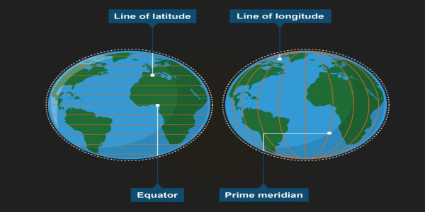
Latitudes are imaginary horizontal lines around the Earth used to measure how far a place is north or south of the Equator. These imaginary lines running east-west are commonly known as the parallels of latitude.
- Equator: The line drawn midway between the North Pole and the South Pole is called the equator. It is the largest circle and divides the globe into two equal halves. The Equator is 0° latitude.
- Northern hemisphere: the region above the equator latitude.
- Southern hemisphere: the region below the equator latitude.
- North Pole: 90° N latitude
- South Pole: 90° S latitude
Important Parallels (latitudes)
Some parallels are significant due to their location on earth. These parallels are usually located at the places marked by temperature and climate differences. The four main important parallels are the Tropic of Cancer, Tropic of Capricorn, Arctic Circle, and Antarctic Circle.
| Parallel / latitude | Significance |
| 1. Tropic of Cancer | The Tropic of Cancer located at 23.5 degrees north of the Equator. - It lies in the Northern Hemisphere.
- It is the northernmost place where the Sun’s rays can fall vertically.
- The regions beyond this parallel receive slanted rays throughout the year.
- Sun rays fall vertically on this parallel around 21 June.
|
| 2. Tropic of Capricorn | The Tropic of Capricorn is located at 23.5 degrees south of the Equator. - It lies in the Southern Hemisphere.
- It is the southernmost place where the Sun’s rays can fall vertically.
- The regions beyond this parallel receive slanted rays throughout the year.
- Sun rays fall vertically on this parallel around 22 December.
|
| 3. Arctic Circle | The Arctic Circle is located at 66.5 degrees north of the Equator. - It lies in the Northern Hemisphere.
- This latitude marks the southernmost point in the Northern Hemisphere where the sun does not set for a full 24 hours during the summer solstice.
- The region between the Arctic Circle and the North Pole is extremely cold.
|
| 4. Antarctic Circle | The Antarctic Circle is located at 66.5 degrees south of the Equator. - It lies in the Southern Hemisphere.
- This latitude marks the southernmost point in the Southern Hemisphere where the sun does not set for a full 24 hours during the winter solstice.
- The region between the Antarctic Circle and the South Pole is extremely cold.
|
Heat Zones of the Earth
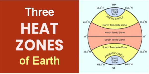
The important parallels of latitude divide the Earth into different heat zones. These heat zones form due to the spherical nature of earth, all parts of earth do not receive equal amounts of sunlight. Three main heat zones:
| Heat zone | Characteristics |
| 1. Torrid Zone | The Torrid zone is the hottest region on earth, lying between the tropic of cancer and the tropic of capricorn. - It is also called the Tropical Zone.
- The Sun’s rays fall almost vertically in this zone. The sun can be directly overhead at least once a year at places within this zone.
|
| 2. Temperate Zones | The Temperate Zones lie between the tropics and the polar circles. There are two Temperate Zones. North Temperate Zone : lies between the Tropic of Cancer and the Arctic Circle. South Temperate Zone : The South Temperate Zone lies between the Tropic of Capricorn and the Antarctic Circle. - This zone receives slanting rays.
- Its climate is generally moderate, not extremely hot and extremely cold.
|
| 3. Frigid Zones | The Frigid Zones lie between the Arctic and Antarctic Circles and the respective poles. There are two Frigid Zones. North Frigid Zone:The North Frigid Zone lies between the Arctic Circle and the North Pole. South Frigid Zone : The South Frigid Zone lies between the Antarctic Circle and the South Pole. - It is the coldest region of the Earth.
- It receives very slanting sunlight.
|
Longitudes
Longitudes are imaginary vertical lines running from the North Pole to the South Pole. They measure how far a place lies east or west of the Prime Meridian. They are called the meridians of longitude. They are spaced farthest apart at the equator and converge at a point at each pole
- Prime Meridian: The Prime Meridian is the longitude marked 0 degrees longitude. It passes through Greenwich, a place near London in the United Kingdom. It divides the Earth into two equal halves: the Eastern Hemisphere and the Western Hemisphere
- Longitudes range from 0° to 180° East (E) and 0° to 180° West (W).
- All meridians meet at the North and South Poles.
- 180° E and 180° W represent the same meridian, roughly corresponding to the International Date Line.
- Unlike parallels of latitude, meridians are not complete circles; each meridian is a semicircle.
- All meridians are equal in length and meet at both poles. They are farthest apart at the Equator and gradually come closer as they move towards the poles.
Longitude and Distance
The distance between the two longitudes is not the same everywhere. The distance between the two longitudes is maximum at the equator and decreases towards the poles.
- At the Equator, the distance between two meridians 1 degrees apart is about 111 kilometres.
- At the poles, all meridians meet and the distance between them is zero.
Longitude And Time
Longitudes are closely connected with time. The Earth rotates from west to east, as it rotates, different longitudes face the Sun at different times. Therefore, places on different longitudes have different local times.
The Earth rotates around an imaginary line called its axis. It takes approximately 24 hours to complete one rotation. Since the Earth rotates from west to east, the Sun appears to rise in the east and set in the west. Places situated towards the east see the sunrise earlier, so their time is ahead of places situated towards the west.
- The Earth rotates 360 degrees in 24 hours.
- In 1 hour, it rotates 15 degrees.
- The Earth takes 4 minutes to rotate through 1 degree of longitude.
Therefore, every 1degree difference in longitude creates a 4 minute difference in local time. Difference between the time of two longitudes is given by the formula:
| Time difference = Difference in longitude × 4 minutes |
International Date Line
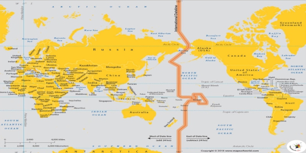
The International Date Line is an imaginary line near 180° longitude that marks the boundary between two consecutive calendar dates.
- It roughly follows 180° longitude in the Pacific Ocean.
- It is not a perfectly straight line because it bends around countries and island groups to avoid dividing territories into different dates.
- It separates two calendar days.
- If you are Crossing the IDL westward then add 1 day.
- If you are crossing the IDL eastward then subtract 1 day.
Local Time
Local time is the time observed at a particular place on Earth, based primarily on its longitude and the position of the Sun. All the places on one longitude experience the same local time.
How is local time determined?
- The Earth rotates 360° in 24 hours.
- Giving roughly 15° of longitude per hour.
- Covering 1° longitude takes around 4 minutes.
- Thus as we move east from Greenwich mean time, local time increases.
- And if we move from the west, the local time decreases.
GMT vs UTC
To calculate and compare the time of different places, the world uses a common reference. This reference is connected with the Prime Meridian. GMT and UTC are related to this reference time.
| Basis of comparison | GMT | UTC |
| Full form | Greenwich Mean Time | Coordinated Universal Time |
| Meaning | Mean solar time at Greenwich | International standard for measuring time |
| Basis | Traditionally based on the average position of the Sun and Earth’s rotation | Mainly based on highly accurate atomic clocks and kept close to Earth’s rotation |
| Use | Older time reference | Modern worldwide time standard |
Standard Time
Standard Time is the official time adopted for an entire country or region, based on a selected standard meridian. It can be different from the actual local time of the place.
Why is Standard Time needed?
Since the Earth rotates 15° of longitude every hour, local time differs from place to place. If every location used its own local time, transport, communication and administration would become difficult. Therefore, countries adopt one or more standard times for practical convenience.
Example: India follows Indian Standard Time (IST).
Standard Meridian: 82°30′ E
Passes near Mirzapur, Uttar Pradesh
IST = UTC + 5:30 .
Why does India have only one standard time?
India has only one official time zone, called Indian Standard Time (IST). India is very wide from east to west, so the Sun rises earlier in the northeast and later in the west. As a result, the local solar time in Arunachal Pradesh is considerably ahead of the local solar time in Gujarat.
India covers roughly 2,900 kilometres from east to west, creating a natural time difference of nearly two hours between its eastern and western parts.
Main reasons:
- Administrative reasons: Government offices and institutions across the country can follow the same timetable.
- Transport coordination: Railways, airlines and buses can prepare common schedules without confusion.
- National unity: One time system provides a common framework for the entire country.
- Economic coordination: Banks, markets, businesses and offices can work according to the same official time.
- Avoiding confusion: Multiple time zones could create difficulties in travel, work timings, official records and communication.
Key Facts: - France has the most time zones in the world, with 12 official time zones.
- Russia has 11 time zones due to its large continental landmass.
- The United States has 11 time zones.
|
Daylight Saving Time
Daylight Saving Time (DST) or summer time is the practice of advancing clocks by one hour during part of the year, usually in spring and summer, so that people get more daylight in the evening.
How is it done?
Usually in the summer season some countries adjust clocks one hour forward and backwards in the autumn to standard time.
Why is DST used?
- More daylight during evening hours in summers.
- Potentially reduce artificial lighting requirements
- Make better use of longer summer daylight .
However, India does not follow this model.